IMAGES TAKEN NEAR TO
Hopfields, MAIDSTONE, ME17 3FR
Introduction
This page details the photographs taken nearby to Hopfields, ME17 3FR by members of the Geograph project.
The Geograph project started in 2005 with the aim of publishing, organising and preserving representative images for every square kilometre of Great Britain, Ireland and the Isle of Man.

There are currently over 7.5m images from over14,400 individuals and you can help contribute to the project by visiting https://www.geograph.org.uk
Image Map
Images are licensed for reuse under creativecommons.org/licenses/by-sa/2.0
Notes
- Clicking on the map will re-center to the selected point.
- The higher the marker number, the further away the image location is from the centre of the postcode.
Image Listing (21 Images Found)
Images are licensed for reuse under creativecommons.org/licenses/by-sa/2.0
Image
Details
Distance
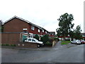
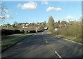
5
South Lane, Sutton Valence
Taken from bus bound for Maidstone.
Image: © Clint Mann
Taken: 16 Feb 2016
0.12 miles
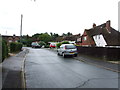
6
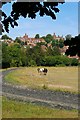
Paddock
This paddock is off South Lane, the village in the background is Sutton Valence.
Image: © Glyn Baker
Taken: 5 Aug 2006
0.14 miles
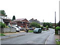
7
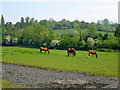
Horses by South Lane
There is a riding circuit around the field.
Image: © Robin Webster
Taken: 22 May 2012
0.19 miles
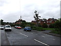
9
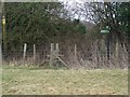
Footpath junction at fenceline
Path No.KH504 from South Lane reaches this stile on fenceline. Then Path No.KH503 leads left up slight hill to Rectory Lane, Sutton Valence. Also the path heads over stile and then follows hedgeline right to Heniker Lane.
Image: © David Anstiss
Taken: 26 Feb 2009
0.21 miles