IMAGES TAKEN NEAR TO
Headcorn Road, MAIDSTONE, ME17 2NH
Introduction
This page details the photographs taken nearby to Headcorn Road, ME17 2NH by members of the Geograph project.
The Geograph project started in 2005 with the aim of publishing, organising and preserving representative images for every square kilometre of Great Britain, Ireland and the Isle of Man.

There are currently over 7.5m images from over14,400 individuals and you can help contribute to the project by visiting https://www.geograph.org.uk
Image Map
Images are licensed for reuse under creativecommons.org/licenses/by-sa/2.0
Notes
- Clicking on the map will re-center to the selected point.
- The higher the marker number, the further away the image location is from the centre of the postcode.
Image Listing (12 Images Found)
Images are licensed for reuse under creativecommons.org/licenses/by-sa/2.0
Image
Details
Distance
2
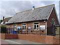
Platt's Heath School
The Classroom is also used as the Assembly Hall and Dining Room
Image: © John Brown
Taken: 1 Sep 2005
0.04 miles
4
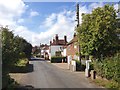
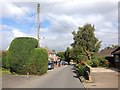
Platt's Heath
Looking towards houses on Headcorn Road.
Image: © Robin Webster
Taken: 9 Jun 2016
0.05 miles
5
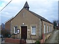
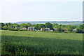
St Edmonds Centre, Platts Heath
On School Lane. Church is now also combined village hall and church.
Image: © David Anstiss
Taken: 22 Feb 2009
0.06 miles
6
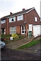
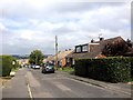
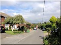
House in Platts Heath
Typical 1960's semi in rural Kent.
Image: © Jonathan Billinger
Taken: 1 Nov 2005
0.08 miles