IMAGES TAKEN NEAR TO
Ham Lane, MAIDSTONE, ME17 2LH
Introduction
This page details the photographs taken nearby to Ham Lane, ME17 2LH by members of the Geograph project.
The Geograph project started in 2005 with the aim of publishing, organising and preserving representative images for every square kilometre of Great Britain, Ireland and the Isle of Man.

There are currently over 7.5m images from over14,400 individuals and you can help contribute to the project by visiting https://www.geograph.org.uk
Image Map
Images are licensed for reuse under creativecommons.org/licenses/by-sa/2.0
Notes
- Clicking on the map will re-center to the selected point.
- The higher the marker number, the further away the image location is from the centre of the postcode.
Image Listing (38 Images Found)
Images are licensed for reuse under creativecommons.org/licenses/by-sa/2.0
Image
Details
Distance
1

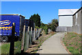
Lenham Storage Distribution Centre
A footpath from Cole Terrace leads through this large lorry park and storage warehouse leading to Old Ham Lane. Path is very well marked out. Lorries all quiet on Sunday but security watching the warehouse.
Image: © David Anstiss
Taken: 22 Feb 2009
0.04 miles
2
Public Footpath through Industrial Estate, Lenham
The footpath runs from Robins Avenue to Ham Lane through the middle of an industrial estate.
It is very well marked, with black and white painted squares to indicate the route in the more exposed places. There are also yellow barriers to protect pedestrians - I was told off by a politically correct foreman from stepping outside the indicated path.
Image: © Chris Heaton
Taken: 12 Aug 2016
0.07 miles
3
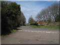
Ham Lane, Lenham
From junction of Old Ham Lane.
Image: © Oast House Archive
Taken: 30 Mar 2009
0.08 miles
4
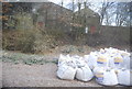
Aggregate bags by the railway line, Lenham
Image: © N Chadwick
Taken: 28 Nov 2010
0.10 miles

6
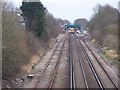
Railway leading to Lenham Station
As seen from Old Ham Lane roadbridge over railway. The train is on the Charing/ Ashford bound lane. The other side leads to Harrietsham/ Maidstone East.
Image: © David Anstiss
Taken: 22 Feb 2009
0.12 miles

8

Mobile Phone Mast, near railway line.
Mast on Old Ham Road, within Balfour Beatty Works area along railway.
Image: © David Anstiss
Taken: 22 Feb 2009
0.13 miles
9
Rough ground by the Maistone East Line, Lenham
Image: © N Chadwick
Taken: 28 Nov 2010
0.14 miles
10

Railway Line at Lenham
Railway line as seen from excursion train.
Image: © Christine Matthews
Taken: 22 Dec 2009
0.14 miles