IMAGES TAKEN NEAR TO
Headcorn Road, MAIDSTONE, ME17 2HT
Introduction
This page details the photographs taken nearby to Headcorn Road, ME17 2HT by members of the Geograph project.
The Geograph project started in 2005 with the aim of publishing, organising and preserving representative images for every square kilometre of Great Britain, Ireland and the Isle of Man.

There are currently over 7.5m images from over14,400 individuals and you can help contribute to the project by visiting https://www.geograph.org.uk
Image Map
Images are licensed for reuse under creativecommons.org/licenses/by-sa/2.0
Notes
- Clicking on the map will re-center to the selected point.
- The higher the marker number, the further away the image location is from the centre of the postcode.
Image Listing (29 Images Found)
Images are licensed for reuse under creativecommons.org/licenses/by-sa/2.0
Image
Details
Distance
1
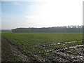
Muddy field near Lenham
A view from the lane running south from the village, looking towards Oxley Wood.
Image: © Stephen Craven
Taken: 30 Jan 2009
0.12 miles
2
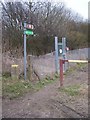
Len Valley Walk on Headcorn Road
The long distance walk leads alongside railway to Lenham Heath Road. Another footpath leads to level crossing leading into Lenham town.
Image: © David Anstiss
Taken: 22 Feb 2009
0.12 miles
3
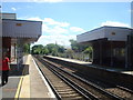
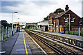
Looking South East from Lenham Station
As seen from the end of the platform on Lenham Railway Station
Image: © Chris Heaton
Taken: 10 Aug 2015
0.15 miles
4
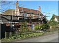
Renovation of Leadingcross Green Farmhouse, Headcorn Road
It is a grade II listed building that is now a house but was formerly a farmhouse. It probably of 15th century origin but was re-fronted in the early 19th century. There are north and west additions that date from the 20th century
http://www.britishlistedbuildings.co.uk/en-173896-leadingcross-green-farmhouse-lenham-kent
Image: © John Baker
Taken: 9 Mar 2014
0.16 miles
5
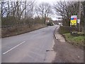
Headcorn Road bridge over railway
Headcorn road from Platt's Heath leads into Lenham. Railway goes underneath bridge in cutting, leading left to Maidstone from Ashford.
Image: © David Anstiss
Taken: 22 Feb 2009
0.16 miles
6
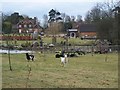
Allsorts in this garden
As seen from footpath from Old Ham Lane to Headocrn Road. This house is called the Lodge, is part of Leading Cross Green farm. Lake in garden had flooded over footpath.
Image: © David Anstiss
Taken: 22 Feb 2009
0.17 miles
7
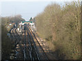
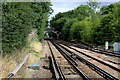
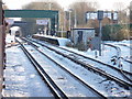
Lenham station - track layout
Lenham has a more complex track layout than most country stations. In this view looking west from the road bridge, there are a siding or goods loop bypassing the station on the left (south, or 'up') side, a trailing crossover just before the platforms, and a goods siding (probably disused) on the north / 'down' side beyond the station. See also Image
Image: © Stephen Craven
Taken: 30 Jan 2009
0.17 miles
8
Lenham Station
Looking along the snow covered track towards Lenham Station.
Image: © Christine Matthews
Taken: 22 Dec 2009
0.17 miles
9
Lenham station, 2002
View west, towards Maidstone and London: ex-SE&CR London - Maidstone East - Ashford secondary main line, electrified east of Maidstone in 1961. Recently an Up loop line had been added (off to the left in this view) for holding Up Continental freight trains after the Channel Tunnel was opened.
Image: © Ben Brooksbank
Taken: 3 Aug 2002
0.18 miles