IMAGES TAKEN NEAR TO
Tanyard Lane, MAIDSTONE, ME17 2FB
Introduction
This page details the photographs taken nearby to Tanyard Lane, ME17 2FB by members of the Geograph project.
The Geograph project started in 2005 with the aim of publishing, organising and preserving representative images for every square kilometre of Great Britain, Ireland and the Isle of Man.

There are currently over 7.5m images from over14,400 individuals and you can help contribute to the project by visiting https://www.geograph.org.uk
Image Map
Images are licensed for reuse under creativecommons.org/licenses/by-sa/2.0
Notes
- Clicking on the map will re-center to the selected point.
- The higher the marker number, the further away the image location is from the centre of the postcode.
Image Listing (37 Images Found)
Images are licensed for reuse under creativecommons.org/licenses/by-sa/2.0
Image
Details
Distance
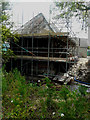
1
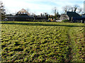
Tanyard Farm, Old Ashford Road
Seen from a public footpath, planning permission was granted by Maidstone Borough Council under application number 14/503309/FULL for the “conversion of 3 agricultural barns for residential use and erection of 3 new dwellings with associated car barns and landscaping”.
Image: © John Baker
Taken: 19 Nov 2017
0.01 miles
2
Tanyard Farm, Old Ashford Road
Planning permission was granted by Maidstone Borough Council under application number 14/503309/FULL for the “conversion of 3 agricultural barns for residential use and erection of 3 new dwellings with associated car barns and landscaping”.
This view of Image was photographed in November 2017, while this view shows Image in November 2020, from a closer perspective.
Image: © John Baker
Taken: 17 Jun 2018
0.02 miles
3
Tanyard Farm, Old Ashford Road
Seen from a public footpath, planning permission was granted by Maidstone Borough Council under application number 14/503309/FULL for the “conversion of 3 agricultural barns for residential use and erection of 3 new dwellings with associated car barns and landscaping”.
The barn conversion, on the other side of the gate, is the same barn before conversion, in the view of Image taken in June 2018.
Image: © John Baker
Taken: 4 Nov 2020
0.03 miles
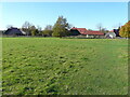
4
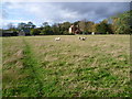
Looking back to Tanyard Farm
This is the footpath from East Lenham past Tanyard Farm to Lenham Church. The sunlight here was rapidly followed by dismal grey skies, then squally rain before the sun came out again at 3.30 to give a rainbow and bright sunshine - see http://www.geograph.org.uk/photo/3726927
Image: © Marathon
Taken: 2 Nov 2013
0.03 miles
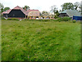
5
Tanyard Farm, Old Ashford Road
Planning permission was granted by Maidstone Borough Council under application number 14/503309/FULL for the “conversion of 3 agricultural barns for residential use and erection of 3 new dwellings with associated car barns and landscaping”.
This is one of the agricultural barns undergoing conversion.
Image: © John Baker
Taken: 17 Jun 2018
0.04 miles
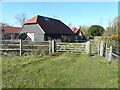
6
Tanyard Farm, Old Ashford Road
Seen from a public footpath, planning permission was granted by Maidstone Borough Council under application number 14/503309/FULL for the “conversion of 3 agricultural barns for residential use and erection of 3 new dwellings with associated car barns and landscaping”.
This view of Image was taken in November 2017, from a closer perspective.
Image: © John Baker
Taken: 4 Nov 2020
0.04 miles
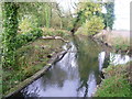
7
Footbridge over Glebe Pond stream
This footpath leads from Tanyard Farm to Lenham Church. It goes over a stream from a pond, one of several sources of the Great Stour.
Image: © David Anstiss
Taken: 4 May 2009
0.04 miles
8
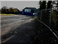
Track to Tanyard Farm, Old Ashford Road
Just visible, beyond the hoarding, are the roof timbers of one of the houses, which is in the process of being built.
Planning permission was granted by Maidstone Borough Council under application number 14/503309/FULL for the “conversion of 3 agricultural barns for residential use and erection of 3 new dwellings with associated car barns and landscaping”.
Image: © John Baker
Taken: 19 Nov 2017
0.05 miles
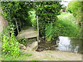
9
Sluice at Tanyard Farm
Seen from the footpath between Lenham Churchyard and Tanyard Farm, this seems to have been the sluice to power a mill which used to exist just behind where I am standing.
Image: © Marathon
Taken: 2 Nov 2013
0.05 miles
10
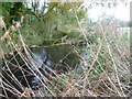
Farmyard pond near Lenham
This pond is next to the footpath between Lenham Churchyard and Tanyard Farm.
Image: © Marathon
Taken: 2 Nov 2013
0.09 miles