IMAGES TAKEN NEAR TO
Rayners Hill, MAIDSTONE, ME17 2DX
Introduction
This page details the photographs taken nearby to Rayners Hill, ME17 2DX by members of the Geograph project.
The Geograph project started in 2005 with the aim of publishing, organising and preserving representative images for every square kilometre of Great Britain, Ireland and the Isle of Man.

There are currently over 7.5m images from over14,400 individuals and you can help contribute to the project by visiting https://www.geograph.org.uk
Image Map
Images are licensed for reuse under creativecommons.org/licenses/by-sa/2.0
Notes
- Clicking on the map will re-center to the selected point.
- The higher the marker number, the further away the image location is from the centre of the postcode.
Image Listing (33 Images Found)
Images are licensed for reuse under creativecommons.org/licenses/by-sa/2.0
Image
Details
Distance
1
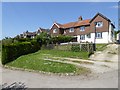
Houses at Rayner's Hill
On the Pilgrim's Way.
Image: © Oliver Dixon
Taken: 13 May 2016
0.01 miles
5
On North Downs Way - View to cottages on Rayner's Hill, Warren Street (close up)
Image: © Colin Park
Taken: 21 Oct 2014
0.02 miles
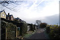
6
North Downs Way heading East towards Rayners Hill
Track adopted by the National Trail, the ancient Pilgrims' Way and Cycle Route No 17.
Image: © Chris Heaton
Taken: 10 Aug 2015
0.03 miles
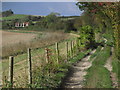
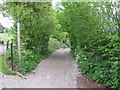
7
North Downs Way heading West away from Rayners Hill
Track adopted by the National Trail, Pilgrims' Way and Cycle Route No. 17.
Image: © Chris Heaton
Taken: 10 Aug 2015
0.03 miles
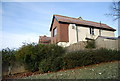
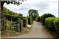
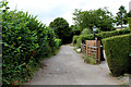
8
Entrance to Highbourne Park
Site of the old Lenham Hospital (Sanatorium), now closed. Converted into a residential estate.
Image: © N Chadwick
Taken: 28 Nov 2010
0.04 miles

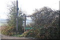
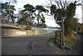
10
North Downs Way on Pilgrims Way
The long distance path heads down a byway heading towards Charing, from Lenham.
It has just crossed Rayners Hill road.
Image: © David Anstiss
Taken: 4 May 2009
0.06 miles