IMAGES TAKEN NEAR TO
Lenham Heath Road, MAIDSTONE, ME17 2BU
Introduction
This page details the photographs taken nearby to Lenham Heath Road, ME17 2BU by members of the Geograph project.
The Geograph project started in 2005 with the aim of publishing, organising and preserving representative images for every square kilometre of Great Britain, Ireland and the Isle of Man.

There are currently over 7.5m images from over14,400 individuals and you can help contribute to the project by visiting https://www.geograph.org.uk
Image Map
Images are licensed for reuse under creativecommons.org/licenses/by-sa/2.0
Notes
- Clicking on the map will re-center to the selected point.
- The higher the marker number, the further away the image location is from the centre of the postcode.
Image Listing (20 Images Found)
Images are licensed for reuse under creativecommons.org/licenses/by-sa/2.0
Image
Details
Distance
1
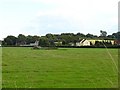
Dead barn at Lenham Heath
Viewed from Crabtree Lane, only the roof remains of this building in the middle of a meadow. The building is marked on the 1:50,000 OS map.
Image: © Penny Mayes
Taken: 29 Aug 2006
0.06 miles
2
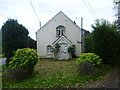
Former chapel at Lenham Heath
This former chapel is on Lenham Heath Road opposite the junction with Crabtree Lane. As can be seen it has now been converted into a house.
Image: © Marathon
Taken: 2 Nov 2013
0.07 miles
3
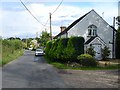
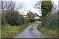
Lenham Heath
This view looks along Lenham Heath Road at the junction with Crabtree Lane. Just ahead is a former chapel, now converted into a house.
Image: © Marathon
Taken: 2 Nov 2013
0.08 miles
4
Lenham Heath
The building on the right looks like a converted Methodist Chapel although it is still marked as a place of worship on the current map. Looking east along Lenham Heath Road.
Image: © Penny Mayes
Taken: 29 Aug 2006
0.10 miles
5
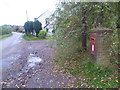
Lane, Lenham Heath
Heading towards Lenham Heath Road.
Image: © Robin Webster
Taken: 13 Jan 2019
0.12 miles
6
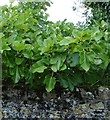
Fig tree at Crabbe Farm
Peeping over the stone wall of Image, Crab Tree Lane, Lenham Heath.
Image: © Penny Mayes
Taken: 29 Aug 2006
0.16 miles
7
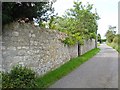
Crabbe Farm
On Crabtree Lane, Lenham Heath. The stone wall effectively conceals the building from view but I gather from the listing details that it is a 17th century farmhouse with the ground floor in stone and the upper storey in brick.
Image: © Penny Mayes
Taken: 29 Aug 2006
0.16 miles
8
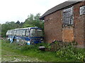
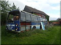
Old coach at Marshall Farm
This coach with registration number AKX 96K clearly would not be of much use to C.D. Smith & Sons of Brenzett now. It is parked up in a field at Marshall Farm next to a footpath and has become even more dilapidated since photographed in 2013 - see https://www.geograph.org.uk/photo/3727060 The back view can be seen at https://www.geograph.org.uk/photo/7171032
Image: © Marathon
Taken: 7 May 2022
0.16 miles
9
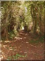
Green lane near Rose Lane
It doesn't go very far, just up to a meadow, but that is bordered by a very old looking hawthorn hedge so it may have been part of an old trackway.
Image: © Penny Mayes
Taken: 29 Aug 2006
0.16 miles
10
Derelict coach at Marshall Farm
This coach with registration number AKX 96K clearly would not be of much use to C.D. Smith & Sons of Brenzett now. It is even more dilapidated than when photographed in 2013 - see https://www.geograph.org.uk/photo/3727061 It is parked up in a field at Marshall Farm next to a footpath. The front view can be seen at https://www.geograph.org.uk/photo/7171036
Image: © Marathon
Taken: 7 May 2022
0.16 miles