IMAGES TAKEN NEAR TO
Lenham Heath Road, MAIDSTONE, ME17 2BP
Introduction
This page details the photographs taken nearby to Lenham Heath Road, ME17 2BP by members of the Geograph project.
The Geograph project started in 2005 with the aim of publishing, organising and preserving representative images for every square kilometre of Great Britain, Ireland and the Isle of Man.

There are currently over 7.5m images from over14,400 individuals and you can help contribute to the project by visiting https://www.geograph.org.uk
Image Map
Images are licensed for reuse under creativecommons.org/licenses/by-sa/2.0
Notes
- Clicking on the map will re-center to the selected point.
- The higher the marker number, the further away the image location is from the centre of the postcode.
Image Listing (31 Images Found)
Images are licensed for reuse under creativecommons.org/licenses/by-sa/2.0
Image
Details
Distance
1
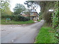
Lenham Heath Road
This is Lenham Heath Road at the junction with Bull Hill on the left. Lenham Heath is a rather strung out hamlet, some two miles from the village of Lenham.
Image: © Marathon
Taken: 2 Nov 2013
0.02 miles
2
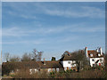
Houses on Lenham Heath Road
A row of properties adjacent to the junction with Bull Hill.
Image: © Stephen Craven
Taken: 30 Jan 2009
0.04 miles
4
St Pancras Bound
A Eurostar heading London bound on the Channel Tunnel rail link
Image: © Glyn Baker
Taken: 31 Jan 2009
0.07 miles
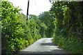
5
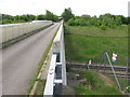
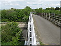
Hubbard's Bridge over CTRL
This is an access road to Hubbard's Farm. It crosses over the Channel Tunnel Rail Link heading left to Ashford/Folkestone from Ebbsfleet/London. The bridge is also used by the Stour Valley Walk (long distance path) heading to Burnt Mill.
Image: © David Anstiss
Taken: 4 May 2009
0.10 miles
7
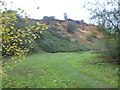
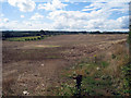
Bull Heath
Bull Heath is a former sand quarry which is now a nature reserve. It is owned and managed by the Heaths Countryside Corridor which is a community-based group working to conserve and enhance the local countryside.
Image: © Marathon
Taken: 2 Nov 2013
0.10 miles
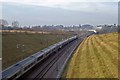
8
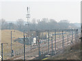
Passing loops for Channel Tunnel freight
As yet there is no regular freight on High Speed One (the dedicated line from the Channel Tunnel to London) but these passing loops near Lenham are provided for it. Viewed from bridge no. 858 in the opposite direction from Image
Image: © Stephen Craven
Taken: 30 Jan 2009
0.10 miles
9
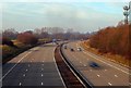
Hubbard's Bridge over M20 Motorway
This is a farm access bridge leading to Hubbard's Farm from Lenham Heath Road.
It passes over the Motorway heading left to Ashford/Folkestone from Maidstone. The bridge is also used by the Stour Valley Walk (long distance path) heading to Burnt Mill from Lenham.
Image: © David Anstiss
Taken: 4 May 2009
0.14 miles
10
Point "C"
Motorways are devices that allow some people to dash from point A to point B very fast whilst other people dash from point B to point A very fast. People living at point C, being directly in between, are often given to thinking what is so good about point A that so many people want to get there from point B and vice versa? They often wish people would work out just where they want to be! P.S. this Point C is close to Hubbard's Farm; the road is the M20 (apologies to Douglas Adams).
Image: © Glyn Baker
Taken: 31 Jan 2009
0.14 miles