IMAGES TAKEN NEAR TO
Bowley Lane, MAIDSTONE, ME17 2BG
Introduction
This page details the photographs taken nearby to Bowley Lane, ME17 2BG by members of the Geograph project.
The Geograph project started in 2005 with the aim of publishing, organising and preserving representative images for every square kilometre of Great Britain, Ireland and the Isle of Man.

There are currently over 7.5m images from over14,400 individuals and you can help contribute to the project by visiting https://www.geograph.org.uk
Image Map
Images are licensed for reuse under creativecommons.org/licenses/by-sa/2.0
Notes
- Clicking on the map will re-center to the selected point.
- The higher the marker number, the further away the image location is from the centre of the postcode.
Image Listing (6 Images Found)
Images are licensed for reuse under creativecommons.org/licenses/by-sa/2.0
Image
Details
Distance

3
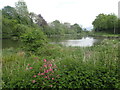
Looking towards Mill Pond at Bowley Farm
Mill Pond id formed by damming the Great Stour at Bowley Mill. For more information about the Great Stour see https://en.wikipedia.org/wiki/River_Stour,_Kent
Image: © Marathon
Taken: 7 May 2022
0.05 miles
4
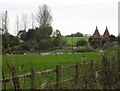
Oasts near Bowley Farm
Just south of the M20 on Bowley Road.
Image: © Penny Mayes
Taken: 7 Nov 2005
0.05 miles
5
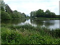
Mill Pond at Bowley Farm
Mill Pond id formed by damming the Great Stour at Bowley Mill. For more information about the Great Stour see https://en.wikipedia.org/wiki/River_Stour,_Kent
Image: © Marathon
Taken: 7 May 2022
0.10 miles
6

Ancient lime tree
In an avenue leading to Chilston Park from Bowley Road. Since the house is listed as "Late C15 or early C16 with C17, C18 and C19 alterations" it seems reasonable to assume this tree (and its fellows) is at least 200 years old. For a view of the avenue see http://www.geograph.org.uk/photo/77100
Image: © Penny Mayes
Taken: 7 Nov 2005
0.14 miles