IMAGES TAKEN NEAR TO
Ashford Road, ME17 1WR
Introduction
This page details the photographs taken nearby to Ashford Road, ME17 1WR by members of the Geograph project.
The Geograph project started in 2005 with the aim of publishing, organising and preserving representative images for every square kilometre of Great Britain, Ireland and the Isle of Man.

There are currently over 7.5m images from over14,400 individuals and you can help contribute to the project by visiting https://www.geograph.org.uk
Image Map
Images are licensed for reuse under creativecommons.org/licenses/by-sa/2.0
Notes
- Clicking on the map will re-center to the selected point.
- The higher the marker number, the further away the image location is from the centre of the postcode.
Image Listing (16 Images Found)
Images are licensed for reuse under creativecommons.org/licenses/by-sa/2.0
Image
Details
Distance
1
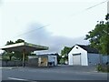
Bearsted Hand Car Wash on Ashford Road
Image: © David Howard
Taken: 12 Jun 2016
0.15 miles
2
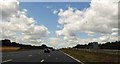
At last free flowing traffic south on the M20
Chaos in Kent due to migrant activity at LeShuttle terminal in France.
Image: © Steve Fareham
Taken: 25 Jul 2015
0.17 miles
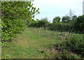
4
Edge of the wood
Footpath south of Snarkhurst Wood http://www.geograph.org.uk/photo/19687 . To the top left of the picture is the west portal of the tunnel which takes the main rail line from Ashford to Maidstone under both the Channel Tunnel Rail Link and the M20 motorway.
Image: © Dennis Turner
Taken: 9 May 2009
0.19 miles
5
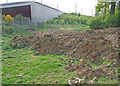
Edge of the wood
Land and footpath south of Snarkhurst Wood http://www.geograph.org.uk/photo/19687 recovering from works connected with building the nearby Channel Tunnel Rail Link.
Image: © Dennis Turner
Taken: 9 May 2009
0.19 miles
6
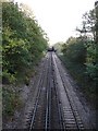
Railway under railway
The Maidstone - Ashford line goes underneath both the M20 motorway (first bridge) and High Speed Rail Link (second bridge) just west of the Crismill Road bridge.
Image: © Penny Mayes
Taken: 14 Nov 2005
0.19 miles
7
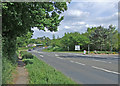
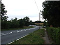
Ashford Road
Busy Bearsted road with entrance to Bearsted caravan site to right of picture.
Image: © Dennis Turner
Taken: 9 May 2009
0.21 miles
8
Edge of the wood
Footpath on the edge of Snarkhurst Wood. http://www.geograph.org.uk/photo/19687
Image: © Dennis Turner
Taken: 9 May 2009
0.23 miles
9
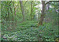
Edge of the wood
Overgrown footpath to the south west of Snarkhurst Wood. http://www.geograph.org.uk/photo/19687
Image: © Dennis Turner
Taken: 9 May 2009
0.23 miles
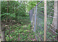
10
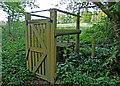
Edge of the wood
Unusual stile on the footpath to the south west of Snarkhurst Wood. http://www.geograph.org.uk/photo/19687 Design of the stile and high fence is thought to be due to the presence of wild boar in the wood.
Image: © Dennis Turner
Taken: 9 May 2009
0.23 miles