IMAGES TAKEN NEAR TO
Hadley Gardens, MAIDSTONE, ME17 1UF
Introduction
This page details the photographs taken nearby to Hadley Gardens, ME17 1UF by members of the Geograph project.
The Geograph project started in 2005 with the aim of publishing, organising and preserving representative images for every square kilometre of Great Britain, Ireland and the Isle of Man.

There are currently over 7.5m images from over14,400 individuals and you can help contribute to the project by visiting https://www.geograph.org.uk
Image Map
Images are licensed for reuse under creativecommons.org/licenses/by-sa/2.0
Notes
- Clicking on the map will re-center to the selected point.
- The higher the marker number, the further away the image location is from the centre of the postcode.
Image Listing (20 Images Found)
Images are licensed for reuse under creativecommons.org/licenses/by-sa/2.0
Image
Details
Distance
1
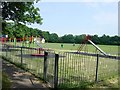
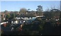
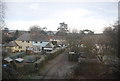
Hollingbourne Recreation Ground
Incorporating a children's playground, cricket pitch and five-a-side soccer pitch. Nicely screened from the road by alternate green and copper beech trees.
Image: © Penny Mayes
Taken: 27 Jun 2005
0.01 miles