IMAGES TAKEN NEAR TO
Lower Street, MAIDSTONE, ME17 1PX
Introduction
This page details the photographs taken nearby to Lower Street, ME17 1PX by members of the Geograph project.
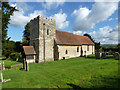
The Geograph project started in 2005 with the aim of publishing, organising and preserving representative images for every square kilometre of Great Britain, Ireland and the Isle of Man.

There are currently over 7.5m images from over14,400 individuals and you can help contribute to the project by visiting https://www.geograph.org.uk
Image Map
Images are licensed for reuse under creativecommons.org/licenses/by-sa/2.0
Notes
- Clicking on the map will re-center to the selected point.
- The higher the marker number, the further away the image location is from the centre of the postcode.
Image Listing (102 Images Found)
Images are licensed for reuse under creativecommons.org/licenses/by-sa/2.0
Image
Details
Distance
1
Swamp on the River Len
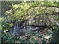
This looks like an overgrown millpond beside the Broomfield Road. There were 23 mills in the Len valley recorded in the Domesday Book so there may have been one here at one time, but not in the last 150 years or so. The river flows from here into the Great Water at Leeds Castle, about 300 metres west. Quite how all these saplings managed to germinate and grow in such a wet environment can only be guessed at.
Image: © Penny Mayes
Taken: 7 Nov 2005
0.02 miles
2
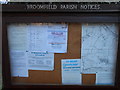
Noticeboard for Broomfield Parish
Containing various church and community notices, and a local map showing the parish boundaries.
Image: © Danny P Robinson
Taken: 1 Jan 2013
0.05 miles
3
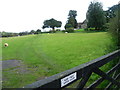
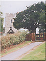
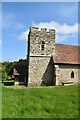
Sheep next to Broomfield Church
This looks over the gate on the track leading up to St Margaret's Church at Broomfield. Although the nave walls are Norman and the west tower is Perpendicular, much of the rest of St Margaret's Church dates from the restoration of 1879.
Image: © Marathon
Taken: 18 Oct 2014
0.06 miles
4
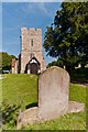
St Margaret's church, Broomfield
A rural church close to Leeds Castle. The building itself sits on a grid line but this is the view from the west.
Image: © Stephen Craven
Taken: Unknown
0.06 miles
5
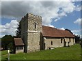
St Margaret's Church, Broomfield
13th century church with 15th century additions (including the tower), restored in 1880. Grade II* listed - see www.historicengland.org.uk/listing/the-list/list-entry/1060942.
Image: © Ian Capper
Taken: 20 Jun 2012
0.06 miles
6
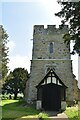
St. Margaret's Church, Broomfield
The church is Grade II* listed and dates from the 11th and 12th centuries with later alterations and restoration in 1879 by G.M.Hall.
Image: © pam fray
Taken: 20 Jul 2020
0.06 miles
9
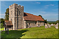
St Margaret's Church, Broomfield
13th century church with 15th century additions (including the tower), restored in 1880. Grade II* listed - see www.historicengland.org.uk/listing/the-list/list-entry/1060942.
Image: © Ian Capper
Taken: 20 Jun 2012
0.06 miles