IMAGES TAKEN NEAR TO
The Hampshires, MAIDSTONE, ME17 1JU
Introduction
This page details the photographs taken nearby to The Hampshires, ME17 1JU by members of the Geograph project.
The Geograph project started in 2005 with the aim of publishing, organising and preserving representative images for every square kilometre of Great Britain, Ireland and the Isle of Man.

There are currently over 7.5m images from over14,400 individuals and you can help contribute to the project by visiting https://www.geograph.org.uk
Image Map
Images are licensed for reuse under creativecommons.org/licenses/by-sa/2.0
Notes
- Clicking on the map will re-center to the selected point.
- The higher the marker number, the further away the image location is from the centre of the postcode.
Image Listing (61 Images Found)
Images are licensed for reuse under creativecommons.org/licenses/by-sa/2.0
Image
Details
Distance
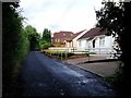
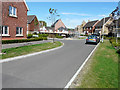
2
New houses on Ashford Road, Harrietsham
These were finished around the end of 2014
Image: © David Howard
Taken: 12 Jun 2016
0.05 miles
4

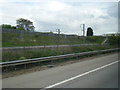
Train on CTRL, beside M20 Motorway and A20
This section of Box tunnel fits the Channel Tunnel Rail Link, in between these two important roads. The motorway (on left) leads to Maidstone and M25 from Ashford/ Folkestone. The A20 (on right) leads to Maidstone from Ashford, via various villages. The train on the link is heading to Ebbsfleet/London from Ashford/Folkestone. It is one of the new 'Javelin' commuter trains being tested out before going into service soon. All seen from Fairbourne Lane bridge No.818.
Image: © David Anstiss
Taken: 24 Feb 2009
0.05 miles
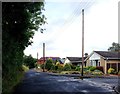
5
The junction of Alexander Road and Horwood Road, The Hollies
The Hollies is the name of the estate (still uncompleted) on which these roads are located, although the map doesn’t show any of the roads at present. Alexander Road is to the left.
Image: © John Baker
Taken: 14 Sep 2014
0.06 miles
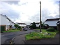
6
Looking east-northeast along Horwood Way
To where a new house is being erected on the corner of Alexander Road. This new housing estate is known as The Hollies.
Image: © John Baker
Taken: 9 Aug 2015
0.06 miles
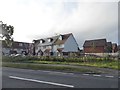
7
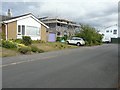
Extension of 14 Quested Way
Planning permission has been granted by Maidstone Borough Council under application numbers 10/1426 for the “erection of first floor side extension and new boundary fencing” and 11/0297 for the “revised rear gutter and roof layout, erection of a close boarded fence and replacement of side windows with double patio doors”
Image: © John Baker
Taken: 18 Aug 2013
0.06 miles
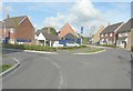
9
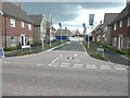
Alexander Road access to The Hollies
According to Maidstone Borough Council's website under planning application 11/0592 The Hollies will comprise of 80 dwellings (including 40% affordable homes) and an area of public open space. There is also access to the site from Ashford Road (A20) and along a path from Hook Lane.
Image: © John Baker
Taken: 18 Aug 2013
0.06 miles
10
Channel Tunnel railway parallels the M20 at Harrietsham
Image: © Colin Pyle
Taken: 13 May 2013
0.07 miles