IMAGES TAKEN NEAR TO
Baldwin's Place, MAIDSTONE, ME17 1JT
Introduction
This page details the photographs taken nearby to Baldwin's Place, ME17 1JT by members of the Geograph project.
The Geograph project started in 2005 with the aim of publishing, organising and preserving representative images for every square kilometre of Great Britain, Ireland and the Isle of Man.

There are currently over 7.5m images from over14,400 individuals and you can help contribute to the project by visiting https://www.geograph.org.uk
Image Map
Images are licensed for reuse under creativecommons.org/licenses/by-sa/2.0
Notes
- Clicking on the map will re-center to the selected point.
- The higher the marker number, the further away the image location is from the centre of the postcode.
Image Listing (70 Images Found)
Images are licensed for reuse under creativecommons.org/licenses/by-sa/2.0
Image
Details
Distance
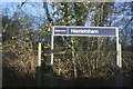
1
West Street, Harrietsham, Kent
View E
Image: © Rodney Burton
Taken: 28 Sep 2005
0.03 miles
2
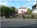
Thornton House, 10 West Street
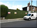
Due to the large conifer in Image having been cut down, I was able to read the house number on the front door and from it obtain details about the two planning applications, relating to this address, on the Maidstone Borough Council’s website. Details of 07/1797 were, “demolition of existing dwelling and erection of a replacement dwelling with integral garage” and 13/1117, “demolition of existing dwelling and erection of replacement 2-storey, six bedroom dwelling with integral garage”. A local passing expressed some astonishment that I seemed to be rating this derelict house as a local landmark!
Image: © John Baker
Taken: 18 Aug 2013
0.04 miles
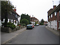
3
West Street
The house on the left (number 10) has boarded up windows. The signpost points to The Wheelwrights - a narrow cul-de-sac.
Image: © John Baker
Taken: 19 May 2013
0.04 miles
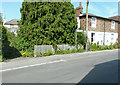
4
Hoarding, 10, West Street
Before the hoarding was erected, one could obtain a view of Image I assume the house has been demolished, as described in Maidstone Borough Council’s planning application 13/1117 as the “demolition of existing dwelling and erection of replacement 2-storey, six bedroom dwelling with integral garage”.
Image: © John Baker
Taken: 7 Aug 2016
0.04 miles
5
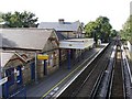
Harrietsham station
Near the northern edge of the square, looking WNW towards Maidstone.
Image: © Penny Mayes
Taken: 9 Oct 2005
0.06 miles
6
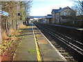
Harrietsham railway station, Kent
Opened in 1884 by the London Chatham & Dover Railway on the line from Swanley to Ashford (Kent). View south east towards Lenham and Ashford.
Image: © Nigel Thompson
Taken: 11 Jan 2014
0.07 miles
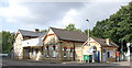
9
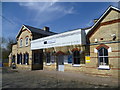
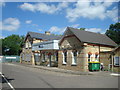
Harrietsham station
The line from Otford to Maidstone East was opened on 1st June 1874 by the London, Chatham & Dover Railway. On 1st July 1884 this was extended from Maidstone East to Ashford with intermediate stations opening at Bearsted, Hollingbourne, Harrietsham, Lenham and Charing on the same day.
Harrietsham station is on the northern edge of the village with open countryside on the other side of the station. A footpath leads away from the down platform across fields to meet the Pilgrim's Way which is also followed here by the North Downs Way. In this photograph the part of the station building to the left has been converted to a children's nursery.
Image: © Marathon
Taken: 23 Apr 2013
0.07 miles