IMAGES TAKEN NEAR TO
West Street, MAIDSTONE, ME17 1JL
Introduction
This page details the photographs taken nearby to West Street, ME17 1JL by members of the Geograph project.
The Geograph project started in 2005 with the aim of publishing, organising and preserving representative images for every square kilometre of Great Britain, Ireland and the Isle of Man.

There are currently over 7.5m images from over14,400 individuals and you can help contribute to the project by visiting https://www.geograph.org.uk
Image Map
Images are licensed for reuse under creativecommons.org/licenses/by-sa/2.0
Notes
- Clicking on the map will re-center to the selected point.
- The higher the marker number, the further away the image location is from the centre of the postcode.
Image Listing (79 Images Found)
Images are licensed for reuse under creativecommons.org/licenses/by-sa/2.0
Image
Details
Distance
1
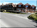
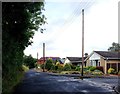
Newly erected houses
Seen from West Street, they are on the corner of Hook Lane.
Image: © John Baker
Taken: 9 Aug 2015
0.02 miles
3
Semi-completed path into The Hollies
From Hook Lane. According to Maidstone Borough Council's website under planning application 11/0592 The Hollies will comprise of 80 dwellings (including 40% affordable homes) and an area of public open space. There is also access to the site from West Street and Ashford Road (A20).
Image: © John Baker
Taken: 18 Aug 2013
0.05 miles
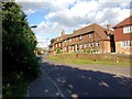
4
West Street, Harrietsham, Kent
View E
Image: © Rodney Burton
Taken: 28 Sep 2005
0.06 miles
6
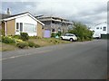
Extension of 14 Quested Way
Planning permission has been granted by Maidstone Borough Council under application numbers 10/1426 for the “erection of first floor side extension and new boundary fencing” and 11/0297 for the “revised rear gutter and roof layout, erection of a close boarded fence and replacement of side windows with double patio doors”
Image: © John Baker
Taken: 18 Aug 2013
0.07 miles
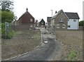
7
Alexander Road entrance to The Hollies
From West Street. According to Maidstone Borough Council's website under planning application 11/0592 The Hollies will comprise of 80 dwellings (including 40% affordable homes) and an area of public open space. There is also access to the site from the A20.
Image: © John Baker
Taken: 19 May 2013
0.08 miles
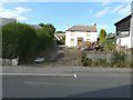
8
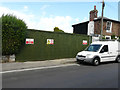
Hoarding, 10, West Street
Before the hoarding was erected, one could obtain a view of Image I assume the house has been demolished, as described in Maidstone Borough Council’s planning application 13/1117 as the “demolition of existing dwelling and erection of replacement 2-storey, six bedroom dwelling with integral garage”.
Image: © John Baker
Taken: 7 Aug 2016
0.08 miles
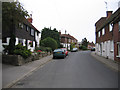
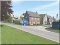
9
West Street
The house on the left (number 10) has boarded up windows. The signpost points to The Wheelwrights - a narrow cul-de-sac.
Image: © John Baker
Taken: 19 May 2013
0.08 miles
10
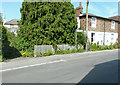
Thornton House, 10 West Street
Due to the large conifer in Image having been cut down, I was able to read the house number on the front door and from it obtain details about the two planning applications, relating to this address, on the Maidstone Borough Council’s website. Details of 07/1797 were, “demolition of existing dwelling and erection of a replacement dwelling with integral garage” and 13/1117, “demolition of existing dwelling and erection of replacement 2-storey, six bedroom dwelling with integral garage”. A local passing expressed some astonishment that I seemed to be rating this derelict house as a local landmark!
Image: © John Baker
Taken: 18 Aug 2013
0.08 miles