IMAGES TAKEN NEAR TO
Alexander Road, MAIDSTONE, ME17 1FG
Introduction
This page details the photographs taken nearby to Alexander Road, ME17 1FG by members of the Geograph project.
The Geograph project started in 2005 with the aim of publishing, organising and preserving representative images for every square kilometre of Great Britain, Ireland and the Isle of Man.

There are currently over 7.5m images from over14,400 individuals and you can help contribute to the project by visiting https://www.geograph.org.uk
Image Map
Images are licensed for reuse under creativecommons.org/licenses/by-sa/2.0
Notes
- Clicking on the map will re-center to the selected point.
- The higher the marker number, the further away the image location is from the centre of the postcode.
Image Listing (64 Images Found)
Images are licensed for reuse under creativecommons.org/licenses/by-sa/2.0
Image
Details
Distance
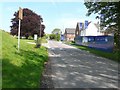
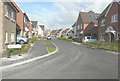
1
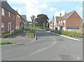
Looking north along Alexander Road, The Hollies
The Hollies is the name of the estate (still uncompleted) on which this road is located, although the map doesn’t show any of the roads at present. The building in the distance is part of Harrietsham Primary School. The view of Image shows the road before access to the estate was permitted.
Image: © John Baker
Taken: 14 Sep 2014
0.01 miles
2
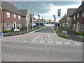
Alexander Road access to The Hollies
According to Maidstone Borough Council's website under planning application 11/0592 The Hollies will comprise of 80 dwellings (including 40% affordable homes) and an area of public open space. There is also access to the site from Ashford Road (A20) and along a path from Hook Lane.
Image: © John Baker
Taken: 18 Aug 2013
0.01 miles
3
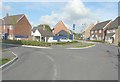
The junction of Alexander Road and Horwood Road, The Hollies
The Hollies is the name of the estate (still uncompleted) on which these roads are located, although the map doesn’t show any of the roads at present. Alexander Road is to the left.
Image: © John Baker
Taken: 14 Sep 2014
0.02 miles
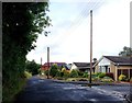
4
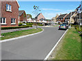
Looking east-northeast along Horwood Way
To where a new house is being erected on the corner of Alexander Road. This new housing estate is known as The Hollies.
Image: © John Baker
Taken: 9 Aug 2015
0.02 miles
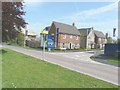
5
The Hollies along West Street
According to Maidstone Borough Council's website under planning application 11/0592 The Hollies will comprise of 80 dwellings (including 40% affordable homes) and an area of public open space. There is also an entrance from the A20. The road to the left takes one to Harrietsham Primary School.
Image: © John Baker
Taken: 19 May 2013
0.03 miles
6
Alexander Road entrance to The Hollies
From West Street. According to Maidstone Borough Council's website under planning application 11/0592 The Hollies will comprise of 80 dwellings (including 40% affordable homes) and an area of public open space. There is also access to the site from the A20.
Image: © John Baker
Taken: 19 May 2013
0.03 miles
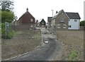
9
Looking east-northeast along Horwood Way, The Hollies
The Hollies is the name of the estate (still uncompleted) on which this road is located, although the map doesn’t show any of the roads at present.
Image: © John Baker
Taken: 14 Sep 2014
0.06 miles
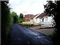
10
Semi-completed path into The Hollies
From Hook Lane. According to Maidstone Borough Council's website under planning application 11/0592 The Hollies will comprise of 80 dwellings (including 40% affordable homes) and an area of public open space. There is also access to the site from West Street and Ashford Road (A20).
Image: © John Baker
Taken: 18 Aug 2013
0.06 miles