IMAGES TAKEN NEAR TO
Ashford Road, MAIDSTONE, ME17 1BN
Introduction
This page details the photographs taken nearby to Ashford Road, ME17 1BN by members of the Geograph project.
The Geograph project started in 2005 with the aim of publishing, organising and preserving representative images for every square kilometre of Great Britain, Ireland and the Isle of Man.

There are currently over 7.5m images from over14,400 individuals and you can help contribute to the project by visiting https://www.geograph.org.uk
Image Map
Images are licensed for reuse under creativecommons.org/licenses/by-sa/2.0
Notes
- Clicking on the map will re-center to the selected point.
- The higher the marker number, the further away the image location is from the centre of the postcode.
Image Listing (30 Images Found)
Images are licensed for reuse under creativecommons.org/licenses/by-sa/2.0
Image
Details
Distance
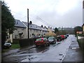
1
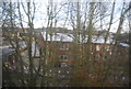
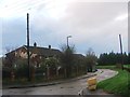
Industrial building through the trees, Harrietsham
This building fits in a plot of land between the railway and the A20.
Image: © N Chadwick
Taken: 28 Nov 2010
0.04 miles
2
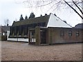
Church on Church Lane, Lenham
This modern church did not have any signposts or details in the windows to tell visitors about it.
Image: © David Anstiss
Taken: 24 Feb 2009
0.09 miles
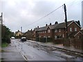
3
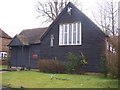
Catholic Church of the Good Shepherd
On Rectory Lane. What is now the Catholic Church of the Good Shepherd, Harrietsham was originally built in 1881 as an Anglican Mission Church for the workers employed on the construction of the London to Dover Railway. After the railway was completed, the whole building became a Mission Church in the 19th century meaning of the term, that is, it tended to be used by the working people of the village, whereas the "gentry" went to the much older Parish Church of St John the Baptist. After the Second World War, the Church of St John the Baptist was repaired and less and less use was made of the Church of the Good Shepherd. By the mid-1960s the sale of the church was being actively considered. After lengthy negotiations, the sale was finally agreed and the Catholic Church of the Good Shepherd came in to use about the year 1970 as part of the Maidstone parish.
Image: © David Anstiss
Taken: 24 Feb 2009
0.09 miles
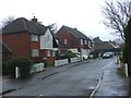
4
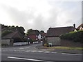
Downlands at the junction of Ashford Road
More new houses trying to look old
Image: © David Howard
Taken: 12 Jun 2016
0.09 miles
8
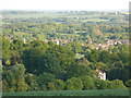
View of Harrietsham
Taken with a zoom lens from the top of a nearby hill.
Image: © Danny P Robinson
Taken: 2 Jun 2013
0.12 miles
10
Old Milestone by the A20, Ashford Road, Harrietsham Parish
Stone post (plates lost) by the A20, in parish of HARRIETSHAM (MAIDSTONE District), Ashford Road, East of village, under railway bridge, in grass bank behind pavement, on North side of road. Maidstone double iron plate, erected by the Ashford & Maidstone turnpike trust in the 19th century.
Inscription reads:- : Maidsto(n)e / (7) : : (Ashford / 11) :
Carved benchmark on remains.
Milestone Society National ID: KE_LF42.
Image: © C Woodward
Taken: 2 Jul 2007
0.15 miles