IMAGES TAKEN NEAR TO
Church Road, MAIDSTONE, ME17 1AL
Introduction
This page details the photographs taken nearby to Church Road, ME17 1AL by members of the Geograph project.
The Geograph project started in 2005 with the aim of publishing, organising and preserving representative images for every square kilometre of Great Britain, Ireland and the Isle of Man.

There are currently over 7.5m images from over14,400 individuals and you can help contribute to the project by visiting https://www.geograph.org.uk
Image Map
Images are licensed for reuse under creativecommons.org/licenses/by-sa/2.0
Notes
- Clicking on the map will re-center to the selected point.
- The higher the marker number, the further away the image location is from the centre of the postcode.
Image Listing (48 Images Found)
Images are licensed for reuse under creativecommons.org/licenses/by-sa/2.0
Image
Details
Distance
2
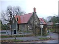
Former Harrietsham Primary School
This school closed in 2006 and was relocated to a nearby site on West Street.
Image: © Chris Whippet
Taken: 27 Nov 2015
0.02 miles
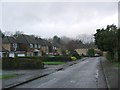
3
Ashford Road, Harrietsham
Looking towards a derelict building
Image: © David Howard
Taken: 12 Jun 2016
0.04 miles
4
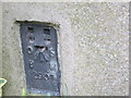
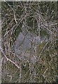
Ordnance Survey Flush Bracket 2907
This can be found on the wall of the old School House - a private dwelling.
For more detail see : http://www.bench-marks.org.uk/bm12005
Image: © Peter Wood
Taken: 17 Feb 2016
0.04 miles
5

Mass bank of Crocuses
Outside Village Hall Carpark and Medical Centre on Church Road.
Harrietsham always has nice flower displays and is well cared for village.
Image: © David Anstiss
Taken: 22 Feb 2009
0.06 miles
6

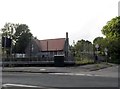
Harrietsham Rail Bridge over Ashford Road
Image: © David Dixon
Taken: 16 May 2013
0.07 miles
7
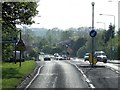
Old Milestone by the A20, Ashford Road, Harrietsham Parish
Stone post (plates lost) by the A20, in parish of HARRIETSHAM (MAIDSTONE District), Ashford Road, East of village, under railway bridge, in grass bank behind pavement, on North side of road. Maidstone double iron plate, erected by the Ashford & Maidstone turnpike trust in the 19th century.
Inscription reads:- : Maidsto(n)e / (7) : : (Ashford / 11) :
Carved benchmark on remains.
Milestone Society National ID: KE_LF42.
Image: © C Woodward
Taken: 2 Jul 2007
0.07 miles
10
Oast House on Church Lane, Harrietsham
Image: © Oast House Archive
Taken: 6 Apr 2015
0.09 miles