IMAGES TAKEN NEAR TO
Chestnut Road, MAIDSTONE, ME16 9FR
Introduction
This page details the photographs taken nearby to Chestnut Road, ME16 9FR by members of the Geograph project.
The Geograph project started in 2005 with the aim of publishing, organising and preserving representative images for every square kilometre of Great Britain, Ireland and the Isle of Man.

There are currently over 7.5m images from over14,400 individuals and you can help contribute to the project by visiting https://www.geograph.org.uk
Image Map
Images are licensed for reuse under creativecommons.org/licenses/by-sa/2.0
Notes
- Clicking on the map will re-center to the selected point.
- The higher the marker number, the further away the image location is from the centre of the postcode.
Image Listing (40 Images Found)
Images are licensed for reuse under creativecommons.org/licenses/by-sa/2.0
Image
Details
Distance
1
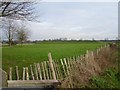
Reservoir near Maidstone Hospital
Seen from the track http://www.geograph.org.uk/photo/331287
Image: © Penny Mayes
Taken: 5 Feb 2007
0.05 miles
2
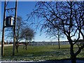
Reservoir
On footpath from Howard Drive to Hermitage Lane.
Image: © David Anstiss
Taken: 4 Jan 2009
0.06 miles
3
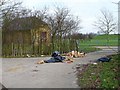
Flytipping by the reservoir
This is what happens when you don't block access tracks :(
Image: © Penny Mayes
Taken: 5 Feb 2007
0.07 miles


8
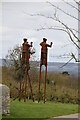
Track to Allington
This track is marked as a public footpath and runs from Hermitage Lane (beside the Hermitage) to Allington, cutting through the new housing estate in Allington. It serves as an access road for the orchards and reservoir.
Image: © Penny Mayes
Taken: 5 Feb 2007
0.12 miles

