IMAGES TAKEN NEAR TO
Terrace Road, MAIDSTONE, ME16 8HU
Introduction
This page details the photographs taken nearby to Terrace Road, ME16 8HU by members of the Geograph project.
The Geograph project started in 2005 with the aim of publishing, organising and preserving representative images for every square kilometre of Great Britain, Ireland and the Isle of Man.

There are currently over 7.5m images from over14,400 individuals and you can help contribute to the project by visiting https://www.geograph.org.uk
Image Map
Images are licensed for reuse under creativecommons.org/licenses/by-sa/2.0
Notes
- Clicking on the map will re-center to the selected point.
- The higher the marker number, the further away the image location is from the centre of the postcode.
Image Listing (212 Images Found)
Images are licensed for reuse under creativecommons.org/licenses/by-sa/2.0
Image
Details
Distance
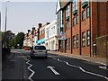
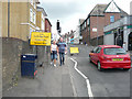
2
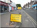
Road signs, Tonbridge Road (A26)
These signs relate to Image
The A26 was closed in both directions to through traffic between Fountain Lane traffic lights and Queen’s Road traffic lights. Traffic was diverted along Terrace Way (A20), London Road (A20), Ashton Way (A228) and Malling Road (A228) and vice versa until it reopened on Sunday 21 October 2018.
Image: © John Baker
Taken: 17 Jun 2018
0.05 miles
3
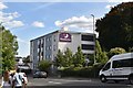
Maidstone: London Road, Rocky Hill
Looking west towards the Premier Inn.
Image: © Michael Garlick
Taken: 28 Apr 2013
0.06 miles
4
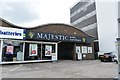
Maidstone: London Road, Rocky Hill
Majestic Wine Warehouse
Image: © Michael Garlick
Taken: 28 Apr 2013
0.06 miles
6
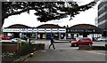
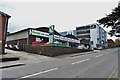
Maidstone: London Road, Rocky Hill
Formula One Autocentre and Majestic Wine Warehouse.
Image: © Michael Garlick
Taken: 28 Apr 2013
0.06 miles
8
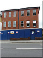
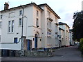
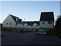
5, Tonbridge Road
Planning permission was granted by Maidstone Borough Council under application number 15/510179/OUT for an “outline application (all matters reserved) for redevelopment with up to 65 dwellings and associated vehicular and pedestrian access, car and cycle parking, street and external lighting, main services, bin stores and other ancillary development”.
The building can also be seen beyond the traffic lights in the image of Image
Image: © John Baker
Taken: 17 Jun 2018
0.06 miles
9
Road signs, Tonbridge Road (A26)
These signs relate to Image
The A26 was closed in both directions to through traffic between Fountain Lane traffic lights and Queen’s Road traffic lights. Traffic was diverted along Terrace Way (A20), London Road (A20), Ashton Way (A228) and Malling Road (A228) and vice versa until it reopened on Sunday 21 October 2018.
Image: © John Baker
Taken: 17 Jun 2018
0.06 miles