IMAGES TAKEN NEAR TO
Westminster Square, MAIDSTONE, ME16 0WQ
Introduction
This page details the photographs taken nearby to Westminster Square, ME16 0WQ by members of the Geograph project.
The Geograph project started in 2005 with the aim of publishing, organising and preserving representative images for every square kilometre of Great Britain, Ireland and the Isle of Man.

There are currently over 7.5m images from over14,400 individuals and you can help contribute to the project by visiting https://www.geograph.org.uk
Image Map
Images are licensed for reuse under creativecommons.org/licenses/by-sa/2.0
Notes
- Clicking on the map will re-center to the selected point.
- The higher the marker number, the further away the image location is from the centre of the postcode.
Image Listing (13 Images Found)
Images are licensed for reuse under creativecommons.org/licenses/by-sa/2.0
Image
Details
Distance
8
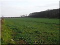
Farmland beside the reservoir
The reservoir seen in http://www.geograph.org.uk/photo/331297 is out of shot to the left. The strip of woodland on the right, combines with the lie of the land to obscure Maidstone Hospital from view. The houses in the background are on estates in Allington.
Image: © Penny Mayes
Taken: 5 Feb 2007
0.21 miles