IMAGES TAKEN NEAR TO
Thyme Walk, MAIDSTONE, ME16 0UU
Introduction
This page details the photographs taken nearby to Thyme Walk, ME16 0UU by members of the Geograph project.
The Geograph project started in 2005 with the aim of publishing, organising and preserving representative images for every square kilometre of Great Britain, Ireland and the Isle of Man.

There are currently over 7.5m images from over14,400 individuals and you can help contribute to the project by visiting https://www.geograph.org.uk
Image Map
Images are licensed for reuse under creativecommons.org/licenses/by-sa/2.0
Notes
- Clicking on the map will re-center to the selected point.
- The higher the marker number, the further away the image location is from the centre of the postcode.
Image Listing (70 Images Found)
Images are licensed for reuse under creativecommons.org/licenses/by-sa/2.0
Image
Details
Distance
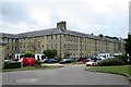
3
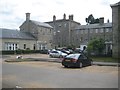
Barming Heath: Former Oakwood Hospital now St Andrew's House (1)
This is the rear of the main central block of the former Oakwood Hospital that was originally built as the Kent County Lunatic Asylum in 1833. It is now a residential apartment block. The building is Grade II Listed and the English Heritage website describes it thus:-
"1833. Architect John Whichcord. 3 storeys ashlar. A long building with a projecting centre and 2 flanking wings. Stringcourses above ground and 1st floors. Cornice and parapet. The latter is slightly higher over the centre of the wings. Behind these higher portions are octagonal turrets on the centre of the roof. Pediment over the centre block with a clock face in the tympanum. 2-storey portico in front of this block with square columns, 3 arches on both floors in the front, those on the ground floor round-headed, those on the 1st floor square-headed, the sides of the ground floor solid, but of the 1st floor open with square-headed arches. Cornice over the whole portico. Glazing bars intact throughout the whole front and also iron grilles over the windows. Large recessed wings of 25 windows each at each end, probably a later addition. They are similar to the main wing, with end projections of 3 windows each."
Comparing the current window configuration with that shown in a photograph taken in 2000 when the building was derelict it is evident that all the windows were formerly of the small size that is visible in a few locations on the wing to the right.
Image: © Nigel Cox
Taken: 25 Jun 2015
0.09 miles
4
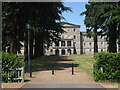
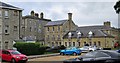
St Andrew's House, Oakwood Hospital, St Andrew's Road, Maidstone, Kent
Former lunatic asylum established in 1833. It was derelict from the 1990's until around 2001 when it was converted to apartments. http://en.wikipedia.org/wiki/Oakwood_Hospital
Grade II listed.
Image: © Oast House Archive
Taken: 1 Jun 2009
0.09 miles
5
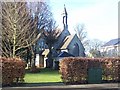
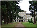
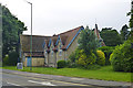
Converted Church within Former Hospital Grounds
Unnamed church, now converted into 'Queen's House' 1-7 Apartments.
Image: © David Anstiss
Taken: 21 Jan 2009
0.09 miles
6
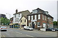
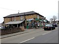
Shops and dentist, Barming Heath
On Tonbridge Road.
Image: © Robin Webster
Taken: 27 Jun 2012
0.10 miles
8
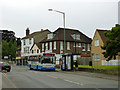
88 bus to Maidstone
Route 88 is a weekday peak hours only service with one run in the morning from Grove Green via central Maidstone to Kingshill ASDA, and two back again in the evening, with the earlier run, this one, only going as far as Maidstone East station.
Image: © Robin Webster
Taken: 27 Jun 2012
0.11 miles