IMAGES TAKEN NEAR TO
Loose Road, MAIDSTONE, ME15 9TX
Introduction
This page details the photographs taken nearby to Loose Road, ME15 9TX by members of the Geograph project.
The Geograph project started in 2005 with the aim of publishing, organising and preserving representative images for every square kilometre of Great Britain, Ireland and the Isle of Man.

There are currently over 7.5m images from over14,400 individuals and you can help contribute to the project by visiting https://www.geograph.org.uk
Image Map
Images are licensed for reuse under creativecommons.org/licenses/by-sa/2.0
Notes
- Clicking on the map will re-center to the selected point.
- The higher the marker number, the further away the image location is from the centre of the postcode.
Image Listing (36 Images Found)
Images are licensed for reuse under creativecommons.org/licenses/by-sa/2.0
Image
Details
Distance

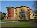
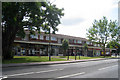
4
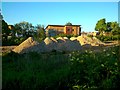
Demolition behind Maidstone Ambulance Station
Viewed from the car park behind the Loose Road shops. This was once an ambulance service building, the site is now about to be redeveloped. The residential buildings in the picture are all too new to appear on the current 1:25000 OS map.
Image: © Danny P Robinson
Taken: 6 May 2014
0.08 miles
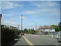
5

Maidstone fire station
Maidstone fire station, Loose Road, Maidstone, Kent, showing a less oblique view than Image
Image: © Kevin Hale
Taken: 17 Oct 2007
0.08 miles
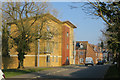
8
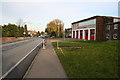
Maidstone Fire Station
Kent Fire and Rescue Service's Maidstone Fire Station and Training Centre situated on the Loose Road, south of Maidstone.
Image: © Richard Sanders
Taken: 29 Nov 2005
0.09 miles
10
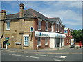
Lloyds TSB Bank, Loose Road
The bank was attacked by ram-raiders a few months after this photo was taken. The cash machine was removed by thieves using a digger, and the bank suffered considerable structural damage as a result. News story here: http://www.bbc.co.uk/news/uk-england-kent-11749778
Image: © Stacey Harris
Taken: 18 Jul 2010
0.09 miles