IMAGES TAKEN NEAR TO
Boughton Lane, MAIDSTONE, ME15 9QW
Introduction
This page details the photographs taken nearby to Boughton Lane, ME15 9QW by members of the Geograph project.
The Geograph project started in 2005 with the aim of publishing, organising and preserving representative images for every square kilometre of Great Britain, Ireland and the Isle of Man.

There are currently over 7.5m images from over14,400 individuals and you can help contribute to the project by visiting https://www.geograph.org.uk
Image Map
Images are licensed for reuse under creativecommons.org/licenses/by-sa/2.0
Notes
- Clicking on the map will re-center to the selected point.
- The higher the marker number, the further away the image location is from the centre of the postcode.
Image Listing (51 Images Found)
Images are licensed for reuse under creativecommons.org/licenses/by-sa/2.0
Image
Details
Distance
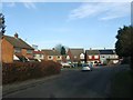
8
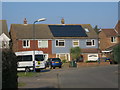
The Farrows, Loose
Viewed from Pheasant Lane, this end of The Farrows is accessible on foot or by pedal cycle only. It is a new development, built on land that used to belong to the Fire Station.
Image: © Danny P Robinson
Taken: 25 Jan 2015
0.13 miles
10
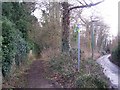
Footpath on Pheasant Lane
Leads past Maidstone Cemetery on left, towards Cliff Hill Road.
Image: © David Anstiss
Taken: 20 Jan 2009
0.13 miles