IMAGES TAKEN NEAR TO
Bockingford Lane, MAIDSTONE, ME15 6DR
Introduction
This page details the photographs taken nearby to Bockingford Lane, ME15 6DR by members of the Geograph project.
The Geograph project started in 2005 with the aim of publishing, organising and preserving representative images for every square kilometre of Great Britain, Ireland and the Isle of Man.

There are currently over 7.5m images from over14,400 individuals and you can help contribute to the project by visiting https://www.geograph.org.uk
Image Map
Images are licensed for reuse under creativecommons.org/licenses/by-sa/2.0
Notes
- Clicking on the map will re-center to the selected point.
- The higher the marker number, the further away the image location is from the centre of the postcode.
Image Listing (43 Images Found)
Images are licensed for reuse under creativecommons.org/licenses/by-sa/2.0
Image
Details
Distance
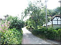
3
Bockingford Mill
Closed in 1892 and converted to a house.
Image: © N Chadwick
Taken: 27 Nov 2011
0.02 miles
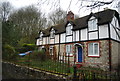
5
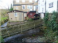
Bockingford Mill over the Loose stream
The Loose stream rises near Langley and flows into the river Medway near Tovil. For several hundred years until the early 20th century, the valley was a local centre of industry with a number of ragstone quarries and a series of 13 water-powered mills. The historian William Lambarde recorded that the mills all existed in 1570. At various times they were engaged in fulling woollen cloth, paper making and corn grinding. They have all either been demolished or long ceased working but the Loose Valley and the sites of the mills were designated a Conservation Area by Maidstone Borough Council in 2000.
This is Bockingford Mill which seems to have been a fulling mill since at least the 17th century. The name of the hamlet probably stems from the word 'bucking' which meant a large wash of coarse linen. By 1839 it is thought that rags which were mostly brought down from London were washed and broken up here to be taken to Hayle Mill, a little way up the valley, for papermaking. By 1856 Bockingford Mill had become a corn mill and around 1900 it ceased operating and was converted into a house. It is now three dwellings and called Bockingford Mill Cottages.
Image: © Marathon
Taken: 18 Jan 2014
0.03 miles
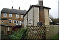
6
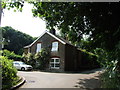
Hayle Mill Cottages, Hayle Mill Road, Loose
Image: © Chris Whippet
Taken: 12 Jul 2013
0.03 miles
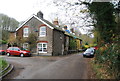
9
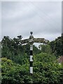
Direction Sign ? Signpost on Teasaucer Hill, Tovil parish
Located on the south side of the T junction of Teasaucer Hill, Bockingford Lane and Hayle Mill Road in Tovil parish. 3 arms and pawn finial.
Milestone Society National ID: KE_TQ7553
Image: © S Brown
Taken: 30 Aug 2021
0.03 miles
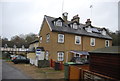
10
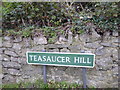
An unusual name
Teasaucer Hill leads steeply down from Cripple Street on the edge of Loose near Maidstone into the Loose Valley at Hayle Mill Road. The name is intriguing and I can only assume it is something to do with the shape of a tea saucer.
Image: © Marathon
Taken: 9 Nov 2019
0.04 miles