IMAGES TAKEN NEAR TO
Smiths Hill, MAIDSTONE, ME15 0PQ
Introduction
This page details the photographs taken nearby to Smiths Hill, ME15 0PQ by members of the Geograph project.
The Geograph project started in 2005 with the aim of publishing, organising and preserving representative images for every square kilometre of Great Britain, Ireland and the Isle of Man.

There are currently over 7.5m images from over14,400 individuals and you can help contribute to the project by visiting https://www.geograph.org.uk
Image Map
Images are licensed for reuse under creativecommons.org/licenses/by-sa/2.0
Notes
- Clicking on the map will re-center to the selected point.
- The higher the marker number, the further away the image location is from the centre of the postcode.
Image Listing (10 Images Found)
Images are licensed for reuse under creativecommons.org/licenses/by-sa/2.0
Image
Details
Distance
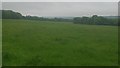
1
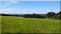
Field off Smith's Hill, West Farleigh (3)
This field is surrounded by a woodland nature reserve and has no means of connecting directly to other fields. The only footpath access to a roadway leads to an unsafe walking route along Smith's Hill. Consequently it is often deserted.
Image: © Danny P Robinson
Taken: 8 Sep 2016
0.14 miles
2
Field off Smith's Hill, West Farleigh (2)
This field is surrounded by a woodland nature reserve and has no means of connecting directly to other fields. The only footpath access to a roadway leads to an unsafe walking route along Smith's Hill. Consequently it is often deserted.
Image: © Danny P Robinson
Taken: 30 May 2016
0.18 miles
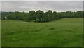
3

Stile, path from Smith's Hill to Ewell Lane
The path does not get used very often. It is at the boundary of a field and a woodland nature reserve. In order to gain access to this field from Smith's Hill it is necessary to walk via an unsafe walking route along Smith's Hill -- that route is not one I recommend.
Image: © Danny P Robinson
Taken: 30 May 2016
0.18 miles
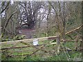
5
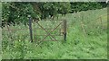
Unused gate, field off Smith's Hill
The gate looks as though it has not been used for some time, and it is not obvious where any former pathway would have led. This field is surrounded by a woodland nature reserve and has no means of connecting directly to other fields. The only footpath access to a roadway leads to an unsafe walking route along Smith's Hill. Consequently it is often deserted.
Image: © Danny P Robinson
Taken: 31 May 2016
0.20 miles
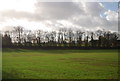
6

Martins' Irish Horses
Not horses, but sheep, are grazing the nearest paddock.
Image: © Robin Webster
Taken: 9 Jul 2012
0.23 miles
7
Quarry Wood Nature Reserve
On footpath No.KA30 from Ewell Lane to Smith's Hill. This section of wood is managed by Kent Wildlife Trust.
Image: © David Anstiss
Taken: 5 Mar 2009
0.23 miles
8
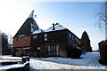
Smiths Hill Oast, Smiths Hill, West Farleigh, Kent
Image: © Oast House Archive
Taken: 4 Feb 2009
0.24 miles
9
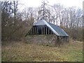
Old Barn near Quarry Wood
Forgotten old barn at edge of Ewell Manor grounds. Seen from footpath No.KA30 from Ewell Lane to Smith's Hill.
Image: © David Anstiss
Taken: 5 Mar 2009
0.24 miles
10
Field off Smith's Hill, West Farleigh (1)
This field is surrounded by a woodland nature reserve and has no means of connecting directly to other fields. The only footpath access to a roadway leads to an unsafe walking route along Smith's Hill. Consequently it is often deserted.
Image: © Danny P Robinson
Taken: 1 Jun 2016
0.24 miles