IMAGES TAKEN NEAR TO
Smiths Hill, MAIDSTONE, ME15 0PH
Introduction
This page details the photographs taken nearby to Smiths Hill, ME15 0PH by members of the Geograph project.
The Geograph project started in 2005 with the aim of publishing, organising and preserving representative images for every square kilometre of Great Britain, Ireland and the Isle of Man.

There are currently over 7.5m images from over14,400 individuals and you can help contribute to the project by visiting https://www.geograph.org.uk
Image Map
Images are licensed for reuse under creativecommons.org/licenses/by-sa/2.0
Notes
- Clicking on the map will re-center to the selected point.
- The higher the marker number, the further away the image location is from the centre of the postcode.
Image Listing (35 Images Found)
Images are licensed for reuse under creativecommons.org/licenses/by-sa/2.0
Image
Details
Distance
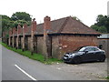
1
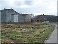
Shingle Barn Farm
On Smith's Hill road. Footpath No.KM24 passes the farm heading downhill through fields to Hunt Street.
Image: © David Anstiss
Taken: 5 Mar 2009
0.00 miles

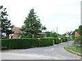
5

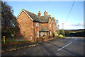
1 and 2, Shingle Barn Cottages
On Smiths Hill opposite the end of Shingle Barn Lane. The brickwork suggests both cottages have been extended in similar fashion, although the roof has weathered seamlessly.
Image: © Robin Webster
Taken: 9 Jul 2012
0.06 miles
6
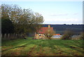
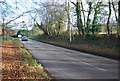
Yalding Hill, Shingle Barn Lane junction
Image: © N Chadwick
Taken: 27 Nov 2011
0.07 miles
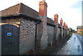
10
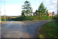
Hoppers Huts on Shingle Barn Lane, Yalding
Image: © Oast House Archive
Taken: 6 Sep 2015
0.08 miles