IMAGES TAKEN NEAR TO
St. Helens Lane, MAIDSTONE, ME15 0LB
Introduction
This page details the photographs taken nearby to St. Helens Lane, ME15 0LB by members of the Geograph project.
The Geograph project started in 2005 with the aim of publishing, organising and preserving representative images for every square kilometre of Great Britain, Ireland and the Isle of Man.

There are currently over 7.5m images from over14,400 individuals and you can help contribute to the project by visiting https://www.geograph.org.uk
Image Map
Images are licensed for reuse under creativecommons.org/licenses/by-sa/2.0
Notes
- Clicking on the map will re-center to the selected point.
- The higher the marker number, the further away the image location is from the centre of the postcode.
Image Listing (69 Images Found)
Images are licensed for reuse under creativecommons.org/licenses/by-sa/2.0
Image
Details
Distance
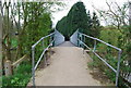
4
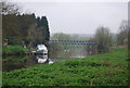
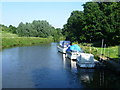
Medway Below Barming Bridge
Looking upstream towards the pedestrian metal bridge which connects Kettle Corner with the Medway Valley Walk. Pleasure boats are moored on the south bank by the bridge.
Image: © Colin Smith
Taken: 26 Apr 2008
0.02 miles
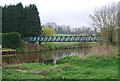
9
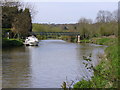
View from Barming Bridge
This view of the River Medway looks downriver from Barming Bridge. The Medway Valley Walk follows the left hand bank. Up until 1740 the river had been fordable at Barming allowing farmers to cross the river to land they owned on either side. In 1740 the River Medway was made navigable and as it had to be deepened it became difficult to cross without a bridge. One was then built. The bridge has been destroyed on two occasions. The first was in 1795 due to flooding, and the second in 1914 when a 10 ton traction engine, which had tried to cross the old wooden bridge, ended up upside down in the water. The old wooden bridge was declared unsafe and replaced by a concrete and steel structure in 1996.
Image: © Marathon
Taken: 26 Jul 2012
0.04 miles
10
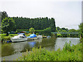
Medway below Barming Bridge
The bridge is a single span steel truss, replacing a three span wooden bridge in 1996. Footbridges both, although the wooden bridge was formerly a road bridge. It collapsed beneath a traction engine in 1914 and was rebuilt. The engine ended up in the river. The recovery must have been tricky.
Image: © Robin Webster
Taken: 27 Jun 2012
0.05 miles