IMAGES TAKEN NEAR TO
Lower Road, MAIDSTONE, ME15 0JN
Introduction
This page details the photographs taken nearby to Lower Road, ME15 0JN by members of the Geograph project.
The Geograph project started in 2005 with the aim of publishing, organising and preserving representative images for every square kilometre of Great Britain, Ireland and the Isle of Man.

There are currently over 7.5m images from over14,400 individuals and you can help contribute to the project by visiting https://www.geograph.org.uk
Image Map
Images are licensed for reuse under creativecommons.org/licenses/by-sa/2.0
Notes
- Clicking on the map will re-center to the selected point.
- The higher the marker number, the further away the image location is from the centre of the postcode.
Image Listing (138 Images Found)
Images are licensed for reuse under creativecommons.org/licenses/by-sa/2.0
Image
Details
Distance
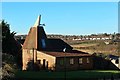
2

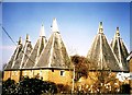
Court Lodge Farm Oast, Lower Road
These oast houses were converted into flats in the 1980s.
Image: © pam fray
Taken: 31 May 2010
0.03 miles
5
Court Lodge Farm Oast, East Farleigh (2)
Image: © N Chadwick
Taken: 13 Apr 2009
0.03 miles
6

Court Lodge Farm Oast, Lower Road, East Farleigh, Kent
Image: © Oast House Archive
Taken: 19 Jun 2008
0.04 miles
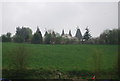
7
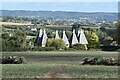
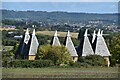
Oasthouses at East Farleigh, seen across fields
This group of oasthouses has been converted to residential use.
Image: © David Martin
Taken: 1 Oct 2022
0.05 miles
8
Oasthouses at East Farleigh
With the Medway Valley and outskirts of Maidstone beyond.
Image: © David Martin
Taken: 1 Oct 2022
0.05 miles
10
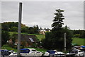
Court Lodge Farm Oast seen across the River Medway
Image: © N Chadwick
Taken: 30 Aug 2011
0.06 miles