IMAGES TAKEN NEAR TO
Church Street, MAIDSTONE, ME15 0BX
Introduction
This page details the photographs taken nearby to Church Street, ME15 0BX by members of the Geograph project.
The Geograph project started in 2005 with the aim of publishing, organising and preserving representative images for every square kilometre of Great Britain, Ireland and the Isle of Man.

There are currently over 7.5m images from over14,400 individuals and you can help contribute to the project by visiting https://www.geograph.org.uk
Image Map
Images are licensed for reuse under creativecommons.org/licenses/by-sa/2.0
Notes
- Clicking on the map will re-center to the selected point.
- The higher the marker number, the further away the image location is from the centre of the postcode.
Image Listing (142 Images Found)
Images are licensed for reuse under creativecommons.org/licenses/by-sa/2.0
Image
Details
Distance
1
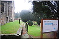
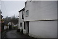
Florence Cottage garden in Loose
This delightful cottage and its garden is in Church Street.
Image: © Marathon
Taken: 5 Jun 2017
0.01 miles
2
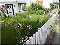
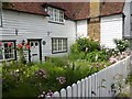
The garden of Florence Cottage in Loose
This delightful cottage and its garden is in Church Street.
Image: © Marathon
Taken: 5 Jun 2017
0.01 miles
3
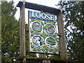
Loose village sign
The name Loose seems to come from the Old English 'hlose' meaning 'place of pigs', probably reflecting the main activity of the local Saxon peasants.
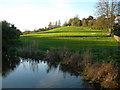
The Loose stream rises near Langley and flows into the river Medway near Tovil. For several hundred years until the early 20th century the valley was a local centre of industry with a number of ragstone quarries and a series of 13 water-powered mills. The historian William Lambarde recorded that the mills all existed in 1570. At various times they were engaged in fulling woollen cloth, paper making and corn grinding. They have all either been demolished or long ceased working but the Loose Valley and the sites of the mills were designated a Conservation Area by Maidstone Borough Council in 2000.
The village sign in Church Street shows the Church of All Saints, a mill wheel and mill, the badge of Kent, and a fish representing the Loose stream.
Loose was also famously the home of the Loose Women's Institute, a counterpart of the Ugley Working Men's Club in Essex.
Image: © Marathon
Taken: 18 Jan 2014
0.02 miles
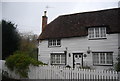
4
The Old Vicarage
Grade II listed. http://www.britishlistedbuildings.co.uk/en-432733-the-old-vicarage-loose
Image: © N Chadwick
Taken: 27 Nov 2011
0.02 miles
5

Florence House
Grade II listed. http://www.britishlistedbuildings.co.uk/en-432840-florence-house-and-florence-cottage-loos
Image: © N Chadwick
Taken: 27 Nov 2011
0.02 miles
7
Florence Cottage
Grade II listed. http://www.britishlistedbuildings.co.uk/en-432840-florence-house-and-florence-cottage-loos
Image: © N Chadwick
Taken: 27 Nov 2011
0.02 miles
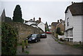
8
Brooks Field, Loose
A popular open space in Loose Village.
Image: © Danny P Robinson
Taken: 6 Apr 2011
0.02 miles
9
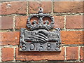
Fire mark of the Hand in Hand Fire & Life Insurance Society on a house in Loose
Fire insurance marks were metal plaques marked with the emblem of the insurance company which were affixed to the front of insured buildings as a guide to the insurance company's fire brigade. These identification marks were used in the 18th and 19th centuries before municipal fire services were formed. Each insurance company maintained its own fire brigade to extinguish fires in those buildings insured by the company and, in return for a fee, in buildings insured by other companies. This was not totally based on goodwill as the fire in a building not insured by a company could easily spread to one which was.
This fire mark of the Hand in Hand Fire & Life Insurance Society is on the front of a house in High Banks, Loose.
Image: © Marathon
Taken: 5 Jun 2017
0.02 miles