IMAGES TAKEN NEAR TO
Manor Rise, MAIDSTONE, ME14 4DA
Introduction
This page details the photographs taken nearby to Manor Rise, ME14 4DA by members of the Geograph project.
The Geograph project started in 2005 with the aim of publishing, organising and preserving representative images for every square kilometre of Great Britain, Ireland and the Isle of Man.

There are currently over 7.5m images from over14,400 individuals and you can help contribute to the project by visiting https://www.geograph.org.uk
Image Map
Images are licensed for reuse under creativecommons.org/licenses/by-sa/2.0
Notes
- Clicking on the map will re-center to the selected point.
- The higher the marker number, the further away the image location is from the centre of the postcode.
Image Listing (48 Images Found)
Images are licensed for reuse under creativecommons.org/licenses/by-sa/2.0
Image
Details
Distance
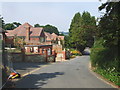
9
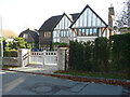
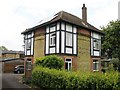
Cherry Tree House, Church Lane
This was Image in June 2018.
Image: © John Baker
Taken: 4 Nov 2020
0.18 miles
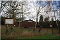
10
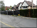
Cherry Tree House, Church Lane
Planning permission was granted by Maidstone Borough Council under application number 16/500334/FULL for the “demolition of existing dwelling. Erection of 2 detached dwellings with new access”. This was Image in November 2020.
The former house was called Tremayne.
Image: © John Baker
Taken: 17 Jun 2018
0.18 miles