IMAGES TAKEN NEAR TO
Aldington Road, MAIDSTONE, ME14 4AN
Introduction
This page details the photographs taken nearby to Aldington Road, ME14 4AN by members of the Geograph project.
The Geograph project started in 2005 with the aim of publishing, organising and preserving representative images for every square kilometre of Great Britain, Ireland and the Isle of Man.

There are currently over 7.5m images from over14,400 individuals and you can help contribute to the project by visiting https://www.geograph.org.uk
Image Map
Images are licensed for reuse under creativecommons.org/licenses/by-sa/2.0
Notes
- Clicking on the map will re-center to the selected point.
- The higher the marker number, the further away the image location is from the centre of the postcode.
Image Listing (23 Images Found)
Images are licensed for reuse under creativecommons.org/licenses/by-sa/2.0
Image
Details
Distance
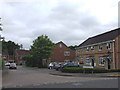
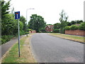
1
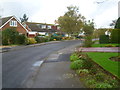
Hampson Way, Roseacre
Roseacre is a suburb of Bearsted, which is now in its turn almost a suburb of Maidstone although the centre of Bearsted is still recognisable as a village.
Image: © Marathon
Taken: 12 Nov 2013
0.06 miles
2
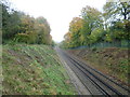
Railway between Maidstone East and Bearsted
The line from Otford to Maidstone East was opened on 1st June 1874 by the London, Chatham & Dover Railway. On 1st July 1884 this was extended from Maidstone East to Ashford with intermediate stations opening at Bearsted, Hollingbourne, Harrietsham, Lenham and Charing on the same day. This view is from a footbridge carrying a path between Weavering Street and Roseacre and looks in the direction of Bearsted.
Image: © Marathon
Taken: 12 Nov 2013
0.09 miles
3
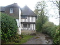
Half-timbered house at Roseacre
A footpath from Weavering Street crosses the railway line between Maidstone East and Bearsted, then drops down into a valley, and uphill on the other side to Roseacre. Just as the modern houses of Roseacre are reached this ancient house can be seen on the left.
Image: © Marathon
Taken: 12 Nov 2013
0.11 miles
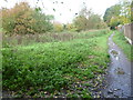
4
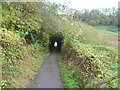
Footpath to Roseacre
A footpath from Weavering Street crosses the railway line between Maidstone East and Bearsted, then drops down into this valley, and uphill on the other side to Roseacre.
Image: © Marathon
Taken: 12 Nov 2013
0.12 miles
6
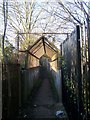
Footbridge over Railway
Leads to Grove Wood Drive from Fauchons Lane. Railway (unseen in cutting) heads left goes to Maidstone East from Bearsted.
Image: © David Anstiss
Taken: 26 Dec 2008
0.13 miles
7
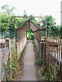
Railway footbridge connecting Grove Green to Bearsted
Image: © Chris Whippet
Taken: 20 Jul 2013
0.13 miles
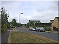
9
Grovewood Drive North, Grove Green
Grovewood Drive North and South were separated for some years by a small patch of ground. Maidstone council reserved the land in case they ever decided to connect the two but recently allowed planning permission for houses to be built there.
Image: © Chris Whippet
Taken: 20 Jul 2013
0.15 miles
10
Footpath at Roseacre
Roseacre is a suburb of Bearsted, which is now in its turn almost a suburb of Maidstone although the centre of Bearsted is still recognisable as a village. This footpath is on the western edge of Roseacre on the edge of a steep valley which drops down to the left here.
Image: © Marathon
Taken: 12 Nov 2013
0.16 miles