IMAGES TAKEN NEAR TO
Ace High Close, MAIDSTONE, ME14 3ND
Introduction
This page details the photographs taken nearby to Ace High Close, ME14 3ND by members of the Geograph project.
The Geograph project started in 2005 with the aim of publishing, organising and preserving representative images for every square kilometre of Great Britain, Ireland and the Isle of Man.

There are currently over 7.5m images from over14,400 individuals and you can help contribute to the project by visiting https://www.geograph.org.uk
Image Map
Images are licensed for reuse under creativecommons.org/licenses/by-sa/2.0
Notes
- Clicking on the map will re-center to the selected point.
- The higher the marker number, the further away the image location is from the centre of the postcode.
Image Listing (9 Images Found)
Images are licensed for reuse under creativecommons.org/licenses/by-sa/2.0
Image
Details
Distance
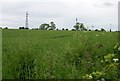
1
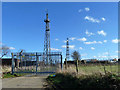
Disused radio station
One of the sites for the short-lived 'Aces High' military radio network of the cold war period, superseded by satellite systems. The only visible remains of this are the far partly derelict buildings. The near tower pre-dated this period, the far one post-dated it (and may still be operational). The Aces High system had two further towers and several dishes, all now dismantled. Some of the remaining buildings now are now put to civil uses, but apparently not on Sundays.
Image: © Robin Webster
Taken: 16 Feb 2014
0.02 miles
2
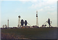
NATO "Ace High" station, Coldblow Lane, Friningham
In May 1983. For information on this defunct military communications network, see http://www.subbrit.org.uk/rsg/features/ace_high/index4.html
The large dishes communicated with the continent by tropospheric scatter. The mast-mounted small dishes are SHF and communicated with Dunkirk (which is west of Canterbury).
For the site in 2005, see Image
Image: © Peter Facey
Taken: 15 May 1983
0.03 miles
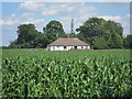
3
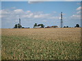
Wireless Transmitting Station
Looking across a wheat field from Coldblow Lane.
Image: © Oast House Archive
Taken: 24 Jul 2011
0.05 miles
4
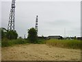
Wireless Transmitting Station
On top of the North Downs near Coldblow Farm this place consists of several derelict buildings. The concrete posts no longer carry barbed wire but presumably the two masts still do something.
Much more information, and an earlier photo Image
Image: © Penny Mayes
Taken: 11 Jun 2005
0.09 miles
5
Wireless Transmitting Station
Viewed from the NNE across a field of wheat.
Image: © Penny Mayes
Taken: 11 Jun 2005
0.11 miles
6
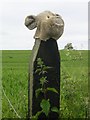
If you go down to the woods today...
Well, it may not be in the woods but it was certainly a surprise. Disembodied teddy bear head on a fence post on Coldblow Lane, near the top of the dip slope of the North Downs just below the Image The crop beyond is wheat.
Image: © Penny Mayes
Taken: 11 Jun 2005
0.12 miles
7
Brickfield Cottages
Looking across a cornfield beside bridleway past Civiley Wood.
Image: © Oast House Archive
Taken: 24 Jul 2011
0.17 miles
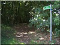
9
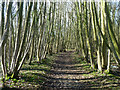
Bridleway through Civiley Wood
A muddy route after much winter rain, this is a better part.
Image: © Robin Webster
Taken: 16 Feb 2014
0.25 miles