IMAGES TAKEN NEAR TO
Water Lane, MAIDSTONE, ME14 3LU
Introduction
This page details the photographs taken nearby to Water Lane, ME14 3LU by members of the Geograph project.
The Geograph project started in 2005 with the aim of publishing, organising and preserving representative images for every square kilometre of Great Britain, Ireland and the Isle of Man.

There are currently over 7.5m images from over14,400 individuals and you can help contribute to the project by visiting https://www.geograph.org.uk
Image Map
Images are licensed for reuse under creativecommons.org/licenses/by-sa/2.0
Notes
- Clicking on the map will re-center to the selected point.
- The higher the marker number, the further away the image location is from the centre of the postcode.
Image Listing (25 Images Found)
Images are licensed for reuse under creativecommons.org/licenses/by-sa/2.0
Image
Details
Distance
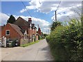
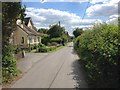
4
Cobham Manor Riding Stables
As seen from footpath from Whitehall Road to Water Lane. North Downs seen in background.
Image: © David Anstiss
Taken: 12 Feb 2009
0.03 miles
6
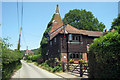
Cobham Oast House, Water Lane, Thurnham, Kent
Image: © Oast House Archive
Taken: 29 Jun 2009
0.05 miles
7
Cobham Oast House, Water Lane, Thurnham, Kent
Image: © Oast House Archive
Taken: 29 Jun 2009
0.05 miles
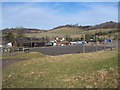
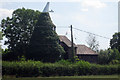
8
Oast House, Cobham Manor
On Water Lane
Image: © David Anstiss
Taken: 12 Feb 2009
0.06 miles
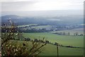
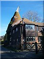
9
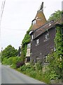
Four Storey Oast Conversion
On Water Lane near Cobham Manor Stables. Unusual for the area in that the oast roundel is stone, possibly recycled from nearby Thurnham Castle.
Image: © Penny Mayes
Taken: 11 Jun 2005
0.08 miles
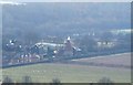
10
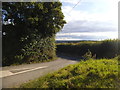
Pilgrims Way at the junction of Water Lane
Image: © David Howard
Taken: 17 Jul 2016
0.08 miles