IMAGES TAKEN NEAR TO
Scragged Oak Road, MAIDSTONE, ME14 3HN
Introduction
This page details the photographs taken nearby to Scragged Oak Road, ME14 3HN by members of the Geograph project.
The Geograph project started in 2005 with the aim of publishing, organising and preserving representative images for every square kilometre of Great Britain, Ireland and the Isle of Man.

There are currently over 7.5m images from over14,400 individuals and you can help contribute to the project by visiting https://www.geograph.org.uk
Image Map
Images are licensed for reuse under creativecommons.org/licenses/by-sa/2.0
Notes
- Clicking on the map will re-center to the selected point.
- The higher the marker number, the further away the image location is from the centre of the postcode.
Image Listing (9 Images Found)
Images are licensed for reuse under creativecommons.org/licenses/by-sa/2.0
Image
Details
Distance
1
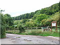
Junction of Whitehill Road, Scragged Oak Road and Magpie Lane, Yelsted
Image: © Chris Whippet
Taken: 27 Aug 2010
0.09 miles
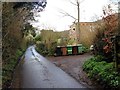
5
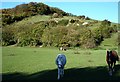
Purple Hill
From White Hill Road (I can't find White Hill on the map) near the south edge of the square.
Image: © Penny Mayes
Taken: 27 Oct 2005
0.16 miles
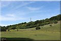
7
Magpie Farm
Looking WSW from Cox Street near the northern edge of the square.
Image: © Penny Mayes
Taken: 27 Oct 2005
0.16 miles
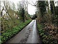
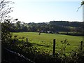
8
Purple Hill
Taken from Scragged Oak Road. Magpie Lane is trackway in valley. It follows hedge from left to right in photo. Could not use because of flooding at the junction with White Hill Road.
Image: © David Anstiss
Taken: 5 Dec 2008
0.22 miles
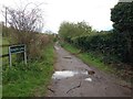
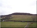
9
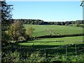
Stone Acre Wood
Looking NW from Cox Street. The hedge line running across the centre of the picture marks the course of the green lane, Magpie Lane.
Image: © Penny Mayes
Taken: 27 Oct 2005
0.25 miles