IMAGES TAKEN NEAR TO
Sandy Lane, MAIDSTONE, ME14 3DJ
Introduction
This page details the photographs taken nearby to Sandy Lane, ME14 3DJ by members of the Geograph project.
The Geograph project started in 2005 with the aim of publishing, organising and preserving representative images for every square kilometre of Great Britain, Ireland and the Isle of Man.

There are currently over 7.5m images from over14,400 individuals and you can help contribute to the project by visiting https://www.geograph.org.uk
Image Map
Images are licensed for reuse under creativecommons.org/licenses/by-sa/2.0
Notes
- Clicking on the map will re-center to the selected point.
- The higher the marker number, the further away the image location is from the centre of the postcode.
Image Listing (35 Images Found)
Images are licensed for reuse under creativecommons.org/licenses/by-sa/2.0
Image
Details
Distance
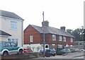
2
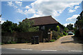
Barn Cottage, Boxley Road, Boxley, Kent
Image: © Oast House Archive
Taken: 14 Jun 2009
0.04 miles
3
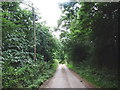
Footpath through Park Wood
Most of the greenery on the ground is bluebell leaves - this wood will look amazing in a few weeks time!
Image: © Richard Dorrell
Taken: 19 Mar 2008
0.11 miles
4
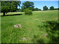
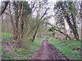
Remains of a building near Sandy Lane
An attractive path leaves Sandy Lane close to Harbourlands Farm to cross what looks like parkland and over the Channel Tunnel Rail Link to reach the outskirts of Boxley. This looks like the foundations of a building.
Image: © Marathon
Taken: 10 Jun 2014
0.11 miles
5
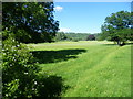
Path at Harbourlands Farm
This attractive path goes across what looks like parkland to cross the Channel Tunnel Rail Link ahead and reach the outskirts of Boxley. The North Downs above Boxley can be seen in the distance.
Image: © Marathon
Taken: 10 Jun 2014
0.11 miles
6
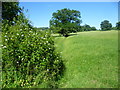
Path to Boxley
This attractive path goes across what looks like parkland to cross the Channel Tunnel Rail Link ahead and reach the outskirts of Boxley.
Image: © Marathon
Taken: 10 Jun 2014
0.13 miles
7

Oast House at Harbourland Farm, Boxley Road, Boxley, Kent
Single round kiln missing roof and cowl.
Image: © Oast House Archive
Taken: 14 Jun 2009
0.15 miles
8
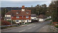
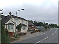
Boxley Road near Maidstone
The North Downs form the backdrop to this image.
Image: © Malc McDonald
Taken: 2 Nov 2013
0.15 miles
9
Harbourland Cottages, Harbourland, near Boxley
This row of cottages was a bit longer before the widening of the M20 in the early 1990s.
Image: © Chris Whippet
Taken: 20 Sep 2010
0.16 miles