IMAGES TAKEN NEAR TO
Boarley Lane, MAIDSTONE, ME14 3BU
Introduction
This page details the photographs taken nearby to Boarley Lane, ME14 3BU by members of the Geograph project.
The Geograph project started in 2005 with the aim of publishing, organising and preserving representative images for every square kilometre of Great Britain, Ireland and the Isle of Man.

There are currently over 7.5m images from over14,400 individuals and you can help contribute to the project by visiting https://www.geograph.org.uk
Image Map
Images are licensed for reuse under creativecommons.org/licenses/by-sa/2.0
Notes
- Clicking on the map will re-center to the selected point.
- The higher the marker number, the further away the image location is from the centre of the postcode.
Image Listing (19 Images Found)
Images are licensed for reuse under creativecommons.org/licenses/by-sa/2.0
Image
Details
Distance
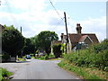
2
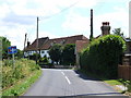
Tyland Lane and Boarley Lane crossroads, Sandling
Image: © Chris Whippet
Taken: 11 Jun 2009
0.03 miles

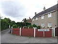
4
Footpath on Grange Lane
Leads across field to gap in conifer hedge, goes to Boarley Oast and onto Pilgrims Way. Part of Kent County Council Centenary Walk, a long distance path.
Image: © David Anstiss
Taken: 26 Dec 2008
0.11 miles

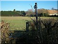
7
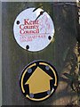
Kent County Council Centenary Walk Markers
Image: © David Anstiss
Taken: 26 Dec 2008
0.13 miles

10
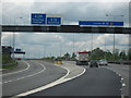
M20 Motorway, Slip Roads for Junctions 6 & 5, Heading West
Image: © Roy Hughes
Taken: 28 Apr 2009
0.18 miles