IMAGES TAKEN NEAR TO
Tyland Lane, MAIDSTONE, ME14 3BH
Introduction
This page details the photographs taken nearby to Tyland Lane, ME14 3BH by members of the Geograph project.
The Geograph project started in 2005 with the aim of publishing, organising and preserving representative images for every square kilometre of Great Britain, Ireland and the Isle of Man.

There are currently over 7.5m images from over14,400 individuals and you can help contribute to the project by visiting https://www.geograph.org.uk
Image Map
Images are licensed for reuse under creativecommons.org/licenses/by-sa/2.0
Notes
- Clicking on the map will re-center to the selected point.
- The higher the marker number, the further away the image location is from the centre of the postcode.
Image Listing (28 Images Found)
Images are licensed for reuse under creativecommons.org/licenses/by-sa/2.0
Image
Details
Distance
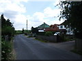
2
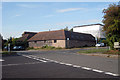
Junction of Chatham Road and Tyland Lane, Sandling
Image: © Chris Whippet
Taken: 11 Jun 2009
0.08 miles
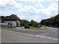
3
Chatham Road, Sandling
This was formerly the A229 Chatham-Maidstone Road.
Image: © Chris Whippet
Taken: 11 Jun 2009
0.09 miles
4
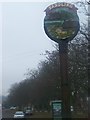
Sandling Village Sign
On Old Chatham Road. Road used to be way to Maidstone from Chatham before the A229 dual carriageway was built.
Image: © David Anstiss
Taken: 16 Dec 2008
0.09 miles
5
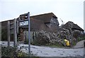
Building on Chatham Road
Converted farm buildings.
Image: © Oast House Archive
Taken: 29 Sep 2009
0.11 miles
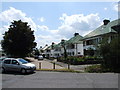
6
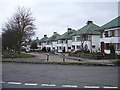
1930s semis on Old Chatham Road
This distinctive row of semis used to line the main A229 Maidstone to Chatham road but the road has now moved several metres east and now runs along the back of their gardens.
Image: © Penny Mayes
Taken: 5 Jan 2006
0.12 miles
7
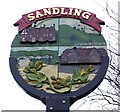
Sandling village sign
Based on ideas submitted by the pupils of Sandling County Primary school in 1993, this sign commemorates the centenary of Boxley Parish Council 1895-1995. It shows Boarley Oast, the North Downs, the River Medway, Tyland Barn and a hop bine.
Image: © Penny Mayes
Taken: 5 Jan 2006
0.12 miles
8
Tyland Barn, Sandling, Maidstone
Home of the headquarters of Kent Wildlife Trust www.kentwildlifetrust.org.uk/ , their Wildlife Centre and the Kent & Medway Biological Records Centre http://www.kmbrc.org.uk/
Image: © Penny Mayes
Taken: 5 Jan 2006
0.12 miles
9
The pond and barn at Tyland Barn
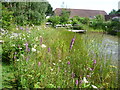
The ground around the originally 17th century Tyland Barn was a level field until 1991. Then part of the grounds was excavated to form a pond and the grounds have subsequently been laid out and managed to illustrate a variety of Kentish habitats and wildlife. Tyland barn is the headquarters of the Kent Wildlife Trust - see http://www.kentwildlifetrust.org.uk/reserves/tyland-barn This is the attractive pond with one of the pond dipping platforms and beyond the original barn which is now the exhibition area, cafe and offices.
Image: © Marathon
Taken: 1 Aug 2012
0.13 miles
10
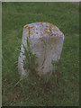
Old Milestone by the former B2097, Old Chatham Road, Sandling
Carved stone post by the UC road (was B2097), in parish of BOXLEY (MAIDSTONE District), junction of access lane with Old Chatham Road, Sandling, by Bakery Cottages, on open grass by lane, on West side of road. Rochester stone, erected by the Rochester & Maidstone turnpike trust in the 19th century.
Inscription reads:-
: 2 / (Mi)l(es) / TO / MAID / STONE : : 5 / Miles / TO / (R)OCHESTER :
Kent HER.
HER Number: TQ 75 NE 890 https://www.heritagegateway.org.uk/Gateway/Results_Single.aspx?uid=MKE78147&resourceID=1005
Milestone Society National ID: KE_MDRC02.
Image: © C Woodward
Taken: 2 Jun 2008
0.13 miles