IMAGES TAKEN NEAR TO
Scarborough Lane, ME1 3ZT
Introduction
This page details the photographs taken nearby to Scarborough Lane, ME1 3ZT by members of the Geograph project.
The Geograph project started in 2005 with the aim of publishing, organising and preserving representative images for every square kilometre of Great Britain, Ireland and the Isle of Man.

There are currently over 7.5m images from over14,400 individuals and you can help contribute to the project by visiting https://www.geograph.org.uk
Image Map
Images are licensed for reuse under creativecommons.org/licenses/by-sa/2.0
Notes
- Clicking on the map will re-center to the selected point.
- The higher the marker number, the further away the image location is from the centre of the postcode.
Image Listing (73 Images Found)
Images are licensed for reuse under creativecommons.org/licenses/by-sa/2.0
Image
Details
Distance
1
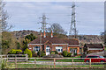
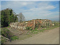
Mill Bay
House on New Court Road, first shown on the 1909 25 inch map, between two tramways taking chalk down to the West Kent Portland Cement Works (alternatively known as the Millbay works) situated by the River Medway, which closed in the 1920s. The route of the more northern of the two tramways is now Scarborough Lane.
Image: © Ian Capper
Taken: 17 Feb 2022
0.00 miles
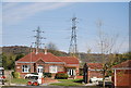
5
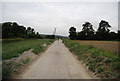
Tramway embankment: Burham
The path to the left ran along the southern boundary of the West Kent cement plant which operated from 1877 to 1925. Chalk and marl was brought to the plant by tramway passing along the embankment of which this is the somewhat eroded base. The tramway bridged the road here, and brickwork of the bridge is still visible. From 1905, rotary kilns were installed, with the stack just to the right of this. For more information, see www.cementkilns.co.uk/cement_kiln_west_kent.html.
Image: © Dylan Moore
Taken: 2 Apr 2014
0.05 miles
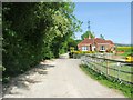
7
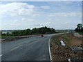
New road leading towards the Peters Village development, near Burham
Image: © Chris Whippet
Taken: 10 May 2015
0.06 miles
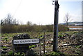
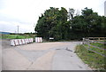
10
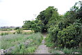
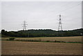
Medway Valley Walk leaves Old Church Rd
Image: © N Chadwick
Taken: 30 Aug 2011
0.08 miles