IMAGES TAKEN NEAR TO
Knowle Road, ROCHESTER, ME1 3XS
Introduction
This page details the photographs taken nearby to Knowle Road, ME1 3XS by members of the Geograph project.
The Geograph project started in 2005 with the aim of publishing, organising and preserving representative images for every square kilometre of Great Britain, Ireland and the Isle of Man.

There are currently over 7.5m images from over14,400 individuals and you can help contribute to the project by visiting https://www.geograph.org.uk
Image Map
Images are licensed for reuse under creativecommons.org/licenses/by-sa/2.0
Notes
- Clicking on the map will re-center to the selected point.
- The higher the marker number, the further away the image location is from the centre of the postcode.
Image Listing (35 Images Found)
Images are licensed for reuse under creativecommons.org/licenses/by-sa/2.0
Image
Details
Distance
3

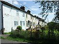
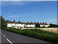
Raven's Knowle Cottages
Built for the nearby quarry
Image: © N Chadwick
Taken: 15 Apr 2010
0.02 miles
6
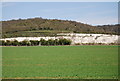
Wouldham Chalk Quarry
A closed quarry.AKA Ravens Knowle Quarry.
Image: © N Chadwick
Taken: 15 Apr 2010
0.15 miles
7
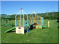
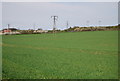
Wouldham Recreation Ground
Wouldham is very typical of a village that was built up by industry (like Snodland on the other side of the River Medway). It was the brick works and cement works here that brought in the workers. This is the recreation ground, next to Knowle Road.
Image: © Marathon
Taken: 10 Jun 2014
0.15 miles