IMAGES TAKEN NEAR TO
Castle Street, ROCHESTER, ME1 3UX
Introduction
This page details the photographs taken nearby to Castle Street, ME1 3UX by members of the Geograph project.
The Geograph project started in 2005 with the aim of publishing, organising and preserving representative images for every square kilometre of Great Britain, Ireland and the Isle of Man.

There are currently over 7.5m images from over14,400 individuals and you can help contribute to the project by visiting https://www.geograph.org.uk
Image Map
Images are licensed for reuse under creativecommons.org/licenses/by-sa/2.0
Notes
- Clicking on the map will re-center to the selected point.
- The higher the marker number, the further away the image location is from the centre of the postcode.
Image Listing (77 Images Found)
Images are licensed for reuse under creativecommons.org/licenses/by-sa/2.0
Image
Details
Distance
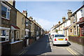
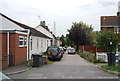
6
High Street, Wouldham
A somewhat narrower High Street than most.
Image: © Robin Webster
Taken: 4 Feb 2007
0.03 miles
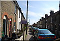
7
Ferry Lane
Until 1963 a ferry across the River Medway left from the bottom of this road.
Image: © N Chadwick
Taken: 30 Aug 2011
0.03 miles
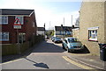
8
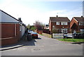
Ferry Lane, Wouldham
Until 1963 a ferry crossed the River Medway to Halling from the end of this road.
Image: © N Chadwick
Taken: 15 Apr 2010
0.03 miles