IMAGES TAKEN NEAR TO
Wouldham Road, ROCHESTER, ME1 3TR
Introduction
This page details the photographs taken nearby to Wouldham Road, ME1 3TR by members of the Geograph project.
The Geograph project started in 2005 with the aim of publishing, organising and preserving representative images for every square kilometre of Great Britain, Ireland and the Isle of Man.

There are currently over 7.5m images from over14,400 individuals and you can help contribute to the project by visiting https://www.geograph.org.uk
Image Map
Images are licensed for reuse under creativecommons.org/licenses/by-sa/2.0
Notes
- Clicking on the map will re-center to the selected point.
- The higher the marker number, the further away the image location is from the centre of the postcode.
Image Listing (5 Images Found)
Images are licensed for reuse under creativecommons.org/licenses/by-sa/2.0
Image
Details
Distance
1
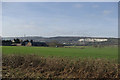
View towards Starkeys
Starkeys is of some antiquity according to the map. The tall chimney is not part of the complex, but a cement works on the far side of the Medway, as is the chalk quarry.
Image: © Robin Webster
Taken: 4 Feb 2007
0.02 miles
2
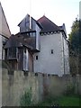
Starkey Castle from Footpath
Footpath leads through ground of Starkey Castle from Rochester Road to River Medway. Starkey Castle is open to visitors with an appointment.
Image: © David Anstiss
Taken: 25 Nov 2008
0.04 miles
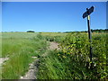
3

Poppy Field near Starkeys
Footpath from Wouldham Road to Pilgrims Way.
Image: © Oast House Archive
Taken: 21 Jun 2010
0.10 miles
4
Footpath to Ivy Cottage
This footpath heads uphill to Burham Road by Ivy Cottage. The other end of the path can be seen at http://www.geograph.org.uk/photo/4023615
Image: © Marathon
Taken: 10 Jun 2014
0.17 miles
5
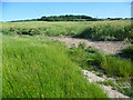
Looking uphill from Wouldham Road
The woodland is just beyond what is marked as an old tip on the Ordnance Survey Map.
Image: © Marathon
Taken: 10 Jun 2014
0.20 miles