IMAGES TAKEN NEAR TO
Rochester Airport Industrial Estate, Maidstone Road, ROCHESTER, ME1 3QY
Introduction
This page details the photographs taken nearby to Rochester Airport Industrial Estate, Maidstone Road, ME1 3QY by members of the Geograph project.
The Geograph project started in 2005 with the aim of publishing, organising and preserving representative images for every square kilometre of Great Britain, Ireland and the Isle of Man.

There are currently over 7.5m images from over14,400 individuals and you can help contribute to the project by visiting https://www.geograph.org.uk
Image Map
Images are licensed for reuse under creativecommons.org/licenses/by-sa/2.0
Notes
- Clicking on the map will re-center to the selected point.
- The higher the marker number, the further away the image location is from the centre of the postcode.
Image Listing (27 Images Found)
Images are licensed for reuse under creativecommons.org/licenses/by-sa/2.0
Image
Details
Distance
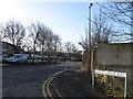
1
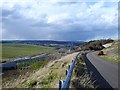
View over the Medway Valley from Stoney Lane, Borstal
Image: © Chris Whippet
Taken: 17 Nov 2009
0.07 miles

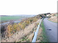
3
Path alongside Stony Lane
Stony Lane leads down from Maidstone Road and is cut through the chalk before crossing over the M2 and then over HS1 before reaching Upper Nashenden Farm. Beyond Upper Nashenden Farm a bridleway leads up between Monk Wood and Syle Wood to reach the North Downs Way at Common Road. Another bridleway leads away from Stony Lane before HS1 is reached and follows a route between HS1 and the M2 to reach the North Downs Way at Nashenden Farm.
This view is just downhill from Maidstone Road. Stony Lane is surprisingly busy with traffic and even this short footpath above it gives a very brief respite from cars and vans. The underlying chalk can be clearly seen.
Image: © Marathon
Taken: 27 Oct 2016
0.10 miles
4

Blossom on Stony Lane
I'm not sure what it is, wild cherry perhaps?
Image: © Penny Mayes
Taken: 18 Mar 2007
0.10 miles
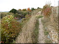
5
Stony Lane
Stony Lane leads down from Maidstone Road and is cut through the chalk before crossing over the M2 and then over HS1 before reaching Upper Nashenden Farm. Beyond Upper Nashenden Farm a bridleway leads up between Monk Wood and Syle Wood to reach the North Downs Way at Common Road. Another bridleway leads away from Stony Lane before HS1 is reached and follows a route between HS1 and the M2 to reach the North Downs Way at Nashenden Farm.
This view is just downhill from Maidstone Road. Stony Lane is surprisingly busy with traffic.
Image: © Marathon
Taken: 27 Oct 2016
0.10 miles
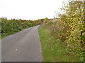
6
Stony Lane over M2 Motorway
Leads to Upper Nashenden Farm, also part of a bridleway from Maidstone Road to Monkwood. Bridge over Channel Tunnel Rail link in background, as well as Monk Wood.
Image: © David Anstiss
Taken: 30 Nov 2008
0.13 miles
7
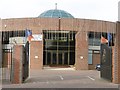
Medway Towns Gurdwara
The Sikh temple of Medway Towns Gurdwara is found on Lankester Parker Road, near to Rochester Airport.
Image: © Marathon
Taken: 27 Oct 2016
0.13 miles
8
Lankester Parker Road
This is Lankester Parker Road, with Rochester Airport at the end of the road ahead. On the left is Medway Towns Gurdwara, and a close up of this Sikh temple can be seen at http://www.geograph.org.uk/photo/5174087
Image: © Marathon
Taken: 27 Oct 2016
0.13 miles
9
Stony Lane, Rochester
Stony Lane snakes down from the Rochester Road, crossing the M2 motorway obliquely on a steep bridge and then crossing the Channel Tunnel Rail Link to give access to Upper Nashenden Farm.
Image: © Penny Mayes
Taken: 18 Mar 2007
0.13 miles