IMAGES TAKEN NEAR TO
Fort Bridgewood, Maidstone Road, ROCHESTER, ME1 3AU
Introduction
This page details the photographs taken nearby to Fort Bridgewood, Maidstone Road, ME1 3AU by members of the Geograph project.
The Geograph project started in 2005 with the aim of publishing, organising and preserving representative images for every square kilometre of Great Britain, Ireland and the Isle of Man.

There are currently over 7.5m images from over14,400 individuals and you can help contribute to the project by visiting https://www.geograph.org.uk
Image Map
Images are licensed for reuse under creativecommons.org/licenses/by-sa/2.0
Notes
- Clicking on the map will re-center to the selected point.
- The higher the marker number, the further away the image location is from the centre of the postcode.
Image Listing (23 Images Found)
Images are licensed for reuse under creativecommons.org/licenses/by-sa/2.0
Image
Details
Distance
1
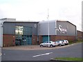
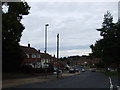
The Sterling Centre, Leisure Facility
On Maidstone Road (B2097).
A multi-purpose sports hall. Has 5-a-side, netball, tennis courts, which are floodlit. Also has a fitness suite, licensed bar and function rooms.
Run by Medway Council. Has a special relationship with Royal Mail, whose distribution centre (on demolished Fort Bridgewood) is opposite the centre.
Image: © David Anstiss
Taken: 12 Nov 2008
0.13 miles
3
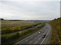
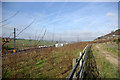
The M2 from Stony Lane bridge
Stony Lane leads down from Maidstone Road and is cut through the chalk before crossing over the M2 and then over HS1 before reaching Upper Nashenden Farm. Beyond Upper Nashenden Farm a bridleway leads up between Monk Wood and Syle Wood to reach the North Downs Way at Common Road. Another bridleway leads away from Stony Lane before HS1 is reached and follows a route between HS1 and the M2 to reach the North Downs Way at Nashenden Farm.
This view looks down towards the Medway Valley with the coast-bound carriageway nearest. The North Downs Way follows the tree line on the left hand hillside.
Image: © Marathon
Taken: 27 Oct 2016
0.14 miles
4
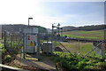
Railway access gate
A sign on the gate labels this CTRL Nashenden Crossover MSP.
Image: © Robin Webster
Taken: 4 Feb 2007
0.17 miles

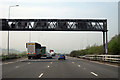
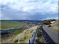
7
Three parallel routes
From the left, the Channel Tunnel Rail Link, a bridleway, and somewhat higher, the M2.
Image: © Robin Webster
Taken: 4 Feb 2007
0.18 miles
9
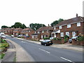
Stony Lane, Rochester
Stony Lane snakes down from the Rochester Road, crossing the M2 motorway obliquely on a steep bridge and then crossing the Channel Tunnel Rail Link to give access to Upper Nashenden Farm.
Image: © Penny Mayes
Taken: 18 Mar 2007
0.19 miles
10
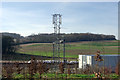
Railway telecommunications mast
By the equipment rooms at Nashenden crossovers on the CTRL.
Image: © Robin Webster
Taken: 4 Feb 2007
0.20 miles