IMAGES TAKEN NEAR TO
Priestfields, ROCHESTER, ME1 3AE
Introduction
This page details the photographs taken nearby to Priestfields, ME1 3AE by members of the Geograph project.
The Geograph project started in 2005 with the aim of publishing, organising and preserving representative images for every square kilometre of Great Britain, Ireland and the Isle of Man.

There are currently over 7.5m images from over14,400 individuals and you can help contribute to the project by visiting https://www.geograph.org.uk
Image Map
Images are licensed for reuse under creativecommons.org/licenses/by-sa/2.0
Notes
- Clicking on the map will re-center to the selected point.
- The higher the marker number, the further away the image location is from the centre of the postcode.
Image Listing (45 Images Found)
Images are licensed for reuse under creativecommons.org/licenses/by-sa/2.0
Image
Details
Distance
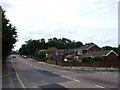
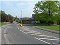
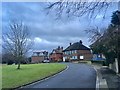
6
Lilymonte Drive, Borstal
This new estate by Bellway Homes as been built along Priestfields.
Image: © David Anstiss
Taken: 22 Jan 2013
0.05 miles
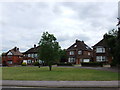
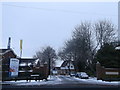
7
Looking towards The Foord Almshouses, Rochester
The Foord Almshouses result from a legacy of Thomas Hellyar Foord, a Mayor of Rochester in the 1880s, and were opened in 1926. This view is from a crescent leading off Priestfields.
Image: © Marathon
Taken: 24 Oct 2011
0.05 miles
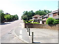
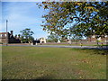
8
Lane leading from Priestfields towards Watts Meadow, Rochester
Image: © Chris Whippet
Taken: 14 Jun 2010
0.06 miles
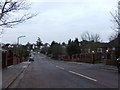
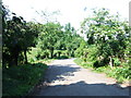
10
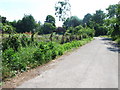
Lane leading from Watt's Meadow towards Priestfields, Rochester
The land either side has been earmarked for development.
Image: © Chris Whippet
Taken: 14 Jun 2010
0.06 miles