IMAGES TAKEN NEAR TO
Clockhouse, FAVERSHAM, ME13 9LU
Introduction
This page details the photographs taken nearby to Clockhouse, ME13 9LU by members of the Geograph project.
The Geograph project started in 2005 with the aim of publishing, organising and preserving representative images for every square kilometre of Great Britain, Ireland and the Isle of Man.

There are currently over 7.5m images from over14,400 individuals and you can help contribute to the project by visiting https://www.geograph.org.uk
Image Map
Images are licensed for reuse under creativecommons.org/licenses/by-sa/2.0
Notes
- Clicking on the map will re-center to the selected point.
- The higher the marker number, the further away the image location is from the centre of the postcode.
Image Listing (18 Images Found)
Images are licensed for reuse under creativecommons.org/licenses/by-sa/2.0
Image
Details
Distance
1
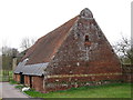
Oast House at Colkins, Clockhouse Lane
Image: © Oast House Archive
Taken: 6 Apr 2015
0.00 miles
2
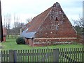
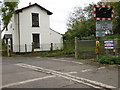
Colkins Barn
A Georgian brick barn adjacent to Colkins http://www.geograph.org.uk/photo/350308. One of a range of brick buildings, the end of the stable block may be seen on the left.
Image: © Penny Mayes
Taken: 26 Feb 2007
0.02 miles
3
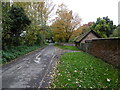
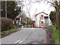
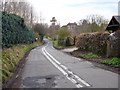
Clockhouse Lane
This is just past Clockhouse Crossing and the house called Colkins is just beyond the wall on the right.
Image: © Marathon
Taken: 23 Oct 2015
0.04 miles
4
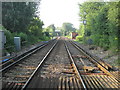
Railway to Faversham, from Clock House Crossing
This railway leads from Canterbury/Dover, through Selling and then over Brenley Lane, towards Faversham, and other stations to London. The M2 Motorway bridge is seen in the background.
Image: © David Anstiss
Taken: 2 Jul 2009
0.04 miles
5
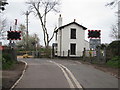
Clock House Crossing
Level crossing near Colkins http://www.geograph.org.uk/photo/350308. The white double line in the middle of the road is a bit of a joke as the lane is not wide enough to accommodate two vehicles side by side and one could not approach the crossing in a car without crossing the lines. I assume it is a strict 'rule' for highway markings by level crossings.
Image: © Penny Mayes
Taken: 26 Feb 2007
0.06 miles
6
Railway crossing, Clockhouse Lane
Image: © Oast House Archive
Taken: 6 Apr 2015
0.06 miles
7
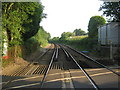
Clockhouse Crossing
The section of the East Kent Railway between Chatham and Faversham opened on 25th January 1858. The continuation from Faversham to Canterbury East was opened on 9th July 1860 by the London, Chatham & Dover Railway. This is Clockhouse Crossing seen from Clockhouse Lane. Faversham is the next station to the left and Selling to the right.
Image: © Marathon
Taken: 23 Oct 2015
0.06 miles
8
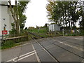
Clockhouse Crossing
The section of the East Kent Railway between Chatham and Faversham opened on 25th January 1858. The continuation from Faversham to Canterbury East was opened on 9th July 1860 by the London, Chatham & Dover Railway. This is Clockhouse Crossing seen from Clockhouse Lane. Faversham is the next station behind and Selling lies ahead on the way to Dover.
Image: © Marathon
Taken: 23 Oct 2015
0.07 miles
9
Lane to Colkins
Colkins http://www.geograph.org.uk/photo/350308 viewed from Image The end of Image may be seen on the right.
Image: © Penny Mayes
Taken: 26 Feb 2007
0.08 miles
10
Railway to Selling, from Clock House Crossing
This railway leads from Faversham, over Brenley Lane, then through Selling towards Canterbury and stations toward Dover.
Image: © David Anstiss
Taken: 2 Jul 2009
0.10 miles