
IMAGES TAKEN NEAR TO
Boughton Hill, FAVERSHAM, ME13 9LE
Introduction
This page details the photographs taken nearby to Boughton Hill, ME13 9LE by members of the Geograph project.
The Geograph project started in 2005 with the aim of publishing, organising and preserving representative images for every square kilometre of Great Britain, Ireland and the Isle of Man.

There are currently over 7.5m images from over14,400 individuals and you can help contribute to the project by visiting https://www.geograph.org.uk
Image Map
Images are licensed for reuse under creativecommons.org/licenses/by-sa/2.0
Notes
- Clicking on the map will re-center to the selected point.
- The higher the marker number, the further away the image location is from the centre of the postcode.
Image Listing (30 Images Found)
Images are licensed for reuse under creativecommons.org/licenses/by-sa/2.0
Image
Details
Distance
2
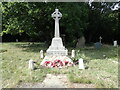
War memorial in the churchyard of the former Christ Church, Dunkirk
Christ Church was erected in 1840. It is built of flint and has a tower containing a clock and one bell. There are three stained windows and a new organ was provided in 1904. The church was restored in 1878, and again in 1907. It is now a private residence, but the churchyard is still accessible. See also https://www.geograph.org.uk/photo/7288720
Image: © Marathon
Taken: 20 Sep 2022
0.03 miles
4
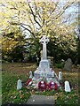
War Memorial, Dunkirk
In the churchyard of the redundant Christ Church, converted to a private dwelling. Some of the churchyard is still accessible to the public.
Image: © pam fray
Taken: 25 Nov 2022
0.04 miles
5
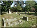
The churchyard of the former Christ Church, Dunkirk
Christ Church was erected in 1840. It is built of flint and has a tower containing a clock and one bell. There are three stained windows and a new organ was provided in 1904. The church was restored in 1878, and again in 1907. It is now a private residence, but the churchyard is still accessible. See also https://www.geograph.org.uk/photo/7288720
Image: © Marathon
Taken: 20 Sep 2022
0.05 miles
6
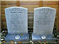
Memorial stones, Christ Church, Dunkirk
These modern stones list the parishioners who are buried in the part of the churchyard that is private property. The redundant Christ Church has been converted to a private dwelling. Some of the churchyard is still accessible to the public.
Image: © pam fray
Taken: 25 Nov 2022
0.05 miles
7
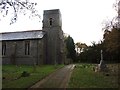
Christ Church, Dunkirk
Redundant since 1988 and now a dwelling.
Image: © Chris Whippet
Taken: 24 Nov 2013
0.05 miles
8
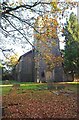
Dunkirk, Kent
Christ Church, Dunkirk, Kent. The village is situated just to the north of the main A2 trunk road, approximately half way between Canterbury and Junction 7 of the M2. The Church has been redundant since 1988.
Image: © Bill Henderson
Taken: Unknown
0.05 miles
9
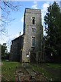
Dunkirk church
Actually taken at 16:09, the church clock had not been adjusted for BST.
Image: © Nick Smith
Taken: 8 Apr 2008
0.05 miles
10
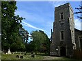
The former Christ Church, Dunkirk
Christ Church was erected in 1840. It is built of flint and has a tower containing a clock and one bell. There are three stained windows and a new organ was provided in 1904. The church was restored in 1878, and again in 1907. It is now a private residence, but the churchyard is still accessible.
Image: © Marathon
Taken: 20 Sep 2022
0.05 miles