IMAGES TAKEN NEAR TO
Dargate, FAVERSHAM, ME13 9JE
Introduction
This page details the photographs taken nearby to ME13 9JE by members of the Geograph project.
The Geograph project started in 2005 with the aim of publishing, organising and preserving representative images for every square kilometre of Great Britain, Ireland and the Isle of Man.

There are currently over 7.5m images from over14,400 individuals and you can help contribute to the project by visiting https://www.geograph.org.uk
Image Map
Images are licensed for reuse under creativecommons.org/licenses/by-sa/2.0
Notes
- Clicking on the map will re-center to the selected point.
- The higher the marker number, the further away the image location is from the centre of the postcode.
Image Listing (7 Images Found)
Images are licensed for reuse under creativecommons.org/licenses/by-sa/2.0
Image
Details
Distance
1
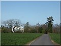
Dargate House
North east of the village of Dargate. It is an early 19th century Grade II* listed building.
Image: © pam fray
Taken: 25 Mar 2021
0.04 miles
3
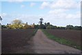
Track to Dargate House
This track leads from another track from Plumpudding Lane to Butler's Hill. Dargate House (on the left) is a regency villa.
Image: © David Anstiss
Taken: 26 Oct 2009
0.17 miles
4
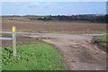
Footpath junction near Dargate
A bridleway from Plumpudding Lane leads left on the metalled track towards Butler's Hill. A footpath leads right across the field past Dargate House to A299 Thanet Way, it also heads left across another field to Butler's Hill near Dargate. The footpaths at this junction do not match the post or the markers.
Image: © David Anstiss
Taken: 26 Oct 2009
0.19 miles

7
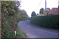
Plumpudding Lane heading to Yorkletts
This lane leads from Dargate.
Image: © David Anstiss
Taken: 26 Oct 2009
0.25 miles