IMAGES TAKEN NEAR TO
Plum Pudding Lane, FAVERSHAM, ME13 9EY
Introduction
This page details the photographs taken nearby to Plum Pudding Lane, ME13 9EY by members of the Geograph project.
The Geograph project started in 2005 with the aim of publishing, organising and preserving representative images for every square kilometre of Great Britain, Ireland and the Isle of Man.

There are currently over 7.5m images from over14,400 individuals and you can help contribute to the project by visiting https://www.geograph.org.uk
Image Map
Images are licensed for reuse under creativecommons.org/licenses/by-sa/2.0
Notes
- Clicking on the map will re-center to the selected point.
- The higher the marker number, the further away the image location is from the centre of the postcode.
Image Listing (34 Images Found)
Images are licensed for reuse under creativecommons.org/licenses/by-sa/2.0
Image
Details
Distance
1
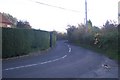
Plumpudding Lane heading to Dargate
This winding lane leads from Yorkletts.
Image: © David Anstiss
Taken: 26 Oct 2009
0.02 miles
4
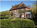
The Old Post Office, Dargate
In Plumpudding Lane. The post office closed in 1990 but the GR postbox is still set in one of the windows. John Spratt, one of the rioters of Bossenden Wood, lived here.
Image: © pam fray
Taken: 25 Mar 2021
0.03 miles
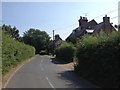
5
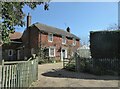
Twin Mays, Dargate
A detached house in Plumpudding Lane.
Image: © pam fray
Taken: 25 Mar 2021
0.05 miles
6
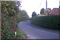
Plumpudding Lane heading to Yorkletts
This lane leads from Dargate.
Image: © David Anstiss
Taken: 26 Oct 2009
0.06 miles
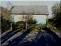
7
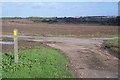
Footpath junction near Dargate
A bridleway from Plumpudding Lane leads left on the metalled track towards Butler's Hill. A footpath leads right across the field past Dargate House to A299 Thanet Way, it also heads left across another field to Butler's Hill near Dargate. The footpaths at this junction do not match the post or the markers.
Image: © David Anstiss
Taken: 26 Oct 2009
0.12 miles
8
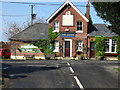
The Dove, Dargate taken from Butler's Hill
The pub is on the junction of Butler's Hill with Dargate Road (to the right) and Plumpudding Lane (to the left)
Image: © Nick Smith
Taken: 8 Apr 2008
0.13 miles
9
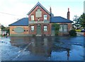
The Dove at Dargate
Seen from Butler's Hill. This pub was built in 1872 on an adjacent site to replace a much earlier inn of the same name. There is a good deal of flowing water around the area, some seems to be caused by burst water mains.
Image: © pam fray
Taken: 2 Jan 2023
0.13 miles
10
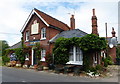
The Dove, Dargate
A late Victorian public house in Plumpudding Lane.
Image: © pam fray
Taken: 11 Jun 2018
0.13 miles