IMAGES TAKEN NEAR TO
Seasalter Road, FAVERSHAM, ME13 9DU
Introduction
This page details the photographs taken nearby to Seasalter Road, ME13 9DU by members of the Geograph project.
The Geograph project started in 2005 with the aim of publishing, organising and preserving representative images for every square kilometre of Great Britain, Ireland and the Isle of Man.

There are currently over 7.5m images from over14,400 individuals and you can help contribute to the project by visiting https://www.geograph.org.uk
Image Map
Images are licensed for reuse under creativecommons.org/licenses/by-sa/2.0
Notes
- Clicking on the map will re-center to the selected point.
- The higher the marker number, the further away the image location is from the centre of the postcode.
Image Listing (59 Images Found)
Images are licensed for reuse under creativecommons.org/licenses/by-sa/2.0
Image
Details
Distance

2
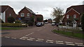
Murton Place, Graveney near Faversham
Murton Place, a modern housing development in the village of Graveney near Faversham. The blue sign indicates that the road is a cul de sac.
Image: © Malc McDonald
Taken: 26 Oct 2013
0.04 miles
3
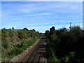
The line to Whitstable
The line between Faversham and Whitstable was opened by the Margate Railway on 1st August 1860 and was extended to Herne Bay on 13th July 1861. This view is from Head Hill Road where a separate footbridge is provided for safety. The view is from the footbridge.
Image: © Marathon
Taken: 20 Sep 2022
0.07 miles
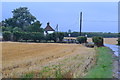
4
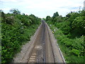
The line to Whitstable
The railway line between Faversham and Whitstable was opened by the Margate Railway on 1st August 1860, and was extended to Herne Bay on 13th July 1861. This is the view from Seasalter Road looking towards Whitstable.
Image: © Marathon
Taken: 28 May 2015
0.08 miles

8

Railway towards Whitstable
From the footbridge, Culmers.
Image: © JThomas
Taken: 22 Jun 2022
0.11 miles
9
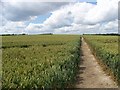
The right of way through a corn field at Graveney
Image: © Elliott Simpson
Taken: 3 Jul 2008
0.12 miles
10
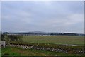
Graveney, All Saints Church: The railway from the churchyard
Image: © Michael Garlick
Taken: 20 Dec 2016
0.12 miles